Maharashtra State Board Class 10 Geography Solutions Chapter 2 Location and Extent
Class 10 Geography Chapter 2 Location and Extent Textbook Questions and Answers
1. Are the sentences right or wrong. ? Rewrite the wrong ones
Question a.
Brazil is mainly located in the Southern Hemisphere.
Answer:
Right
Question b.
Tropic of Capricorn passes through the middle of India.
Answer:
Wrong. Tropic of Cancer passes through the middle of India.
Question c.
The longitudinal extent of Brazil is less than India.
Answer:
Wrong. The longitudinal extent of Brazil is more than India.
Question d.
Equator passes through the northern part of Brazil.
Answer:
Right
Question e.
Brazil has a coastline along the Pacific Ocean.
Answer:
Wrong. Brazil has a coastline along the Atlantic. Ocean.
Question f.
Pakistan is a neighbouring country to the south east of India.
Answer:
Wrong. Pakistan is neighbouring a country to the north west of India.
Question g.
The southern part of India is called Peninsula.
Answer:
Right.
2. Answer in brief:
Question a.
What problems did Brazil and India face after independence?
Answer:
(i) India was under the British rule for almost one- and-a-half centuries and it got its independence in the year 1947.
(ii) It faced several problems like three wars, famine situations in various parts and similar issues after independence.
(iii) Brazil gained its independence in 1822 after more than three centuries of Portuguese rule.
(iv) From 1930 to 1985, for more than a half century, it was under a populist military government and it faced global financial difficulties in the late 20th century.
Thus, both India and Brazil faced many problems post-independence.
Question b.
How are Brazil and India different from each other in terms of location?
Answer:
(i) India is located in the northern hemisphere of the earth whereas some part of Brazil lies in the northern hemisphere and most of it lies in the southern hemisphere.
(ii) India entirely lies in the eastern hemisphere whereas, Brazil lies in the western hemisphere.
(iii) India lies in the continent of Asia whereas Brazil lies in the continent of South America.
(iv) India lies in the southern part of the continent of Asia whereas Brazil lies in the northern part of South American continent.
Question c.
Describe the latitudinal and longitudinal extent of India and Brazil.
Answer:
(i) The extent of the mainland India is 8°4’N to 37°6’N latitudes and between 68°7’E to 97°25’E longitudes.
(ii) Indira Point is the southernmost tip of India.
(iii) It is located on 6°45’N parallel.
(iv) The extent of the mainland Brazil is 5°15’N to 33°45′ S latitudes and between to 34°47’W to 73°48’W longitude.
Select the correct option
Question a.
India’s southernmost point is known as __________.
(a) Lakshadweep
(b) Kanyakumari
(c) Indira Point
(d) Port Blair
Answer:
(c) Indira Point
Question b.
These two countries in South America do not share their border with Brazil?
(a) Chile – Ecuador
(b) Argentina – Bolivia
(c) Columbia – French Guiana
(d) Surinam – Uruguay
Answer:
(a) Chile – Ecuador
Question c.
Both the countries have _________ type of government.
Military
(b) Republic
Communist
(d) Presidential
Answer:
(b) Republic
Question d.
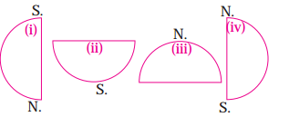
Which of the following shapes show the coastal part of Brazil correctly?
Answer:
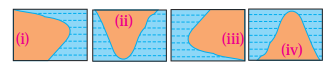
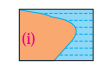
Question e.
Which of the following shapes show the coastal part of India Correctly?
Answer:
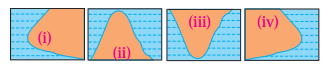

Question f.
Considering hemisphere, which shape correctly represents the hemisphere in which India lies?
Answer:
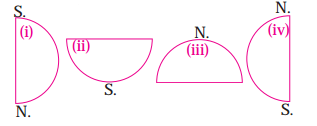
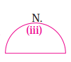
Question g.
Considering the hemisphere, which correctly represents the hemisphere in which Brazil mainly lies?
Answer:

Class 10 Geography Chapter 2 Location and Extent Intext Questions and Answers
Colours of both
Answer the following questions with respect to the countries that you have studied.
Brazil:
The national emblem of Brazil is coat of arms shows the Southern cross in a blue circle. The ring of 27 stars around it represents Brazil’s 26 states and the Federal District. The whole is placed on a star and surrounded by coffee (at the left) and tobacco (at the right), which are the important crops in Brazil. The blue ribbon contains the official name of Brazil (Republica Federativa Do Brazil – Federative Republic of Brazil) in the first line. In the second, the date of the federative republic’s establishment (November 15, 1889) is written.
Give it a try.
Match the column:
Column ‘A’ | Column ‘B’ |
(1) Dance form of Brazil(2) Capital of India(3) Capital of Brazil(4) Coffee pot of world | (a) Brazil(b) Samba(c) New Delhi(d) Brasilia(e) Bangladesh(f) Myanmar |
1 – b
2 – c
3 – d
4 – a
Question 2
Maharashtra Board Solution
Solution & Step-by-Step Answer:
1 – b
2 – c 3 – d 4 – e Answer the following questions in one sentence:
Question 1
Maharashtra Board Solution
Which is the second largest populated country in the world?
Solution & Step-by-Step Answer:
India is the second-largest populated country in the world.
Question 2
Maharashtra Board Solution
Which country is called the ‘coffee pot’ of the world’?
Solution & Step-by-Step Answer:
Brazil is called the coffee pot of the world.
Question 3
Maharashtra Board Solution
Which dance form is famous in Brazil?
Solution & Step-by-Step Answer:
Samba is the famous dance form of Brazil.
Question 4
Maharashtra Board Solution
Name the capital of India?
Solution & Step-by-Step Answer:
The capital of India is New Delhi.
Question 5
Maharashtra Board Solution
When did India gain Independence?
Solution & Step-by-Step Answer:
India got independence on 15th August 1947.
Question 6
Maharashtra Board Solution
When did Brazil gain independence?
Solution & Step-by-Step Answer:
Brazil gained its independence on 7th September 1822.
Question 7
Maharashtra Board Solution
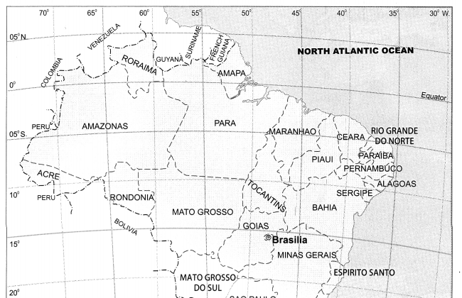
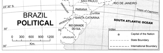
Which countries are located to the north of Brazil?
Solution & Step-by-Step Answer:
Venezuela, Guyana, Suriname and French Guiana are situated to the north of Brazil
Question 8
Maharashtra Board Solution
Which countries are located to the west of Brazil?
Solution & Step-by-Step Answer:
Colombia, Peru, Bolivia, Paraguay and Argentina are situated to the west of Brazil.
Question 9
Maharashtra Board Solution
Which country is situated to the south of Brazil?
Solution & Step-by-Step Answer:
Uruguay is situated to the south of Brazil.
Question 10
Maharashtra Board Solution
Which ocean lies to the east of Brazil?
Solution & Step-by-Step Answer:
The North and South Atlantic Ocean lies to the east of Brazil.
Question 11
Maharashtra Board Solution
Which countries are situated to the east of India?
Solution & Step-by-Step Answer:
Myanmar and Bangladesh are situated to the east of India.
Question 12
Maharashtra Board Solution
Which countries are situated to the north of India?
Solution & Step-by-Step Answer:
China, Bhutan and Nepal are situated to the north of India.
Question 13
Maharashtra Board Solution
Which sea lies to the west of India?
Solution & Step-by-Step Answer:
Arabian sea lies to the west of India.
Question 14
Maharashtra Board Solution
Which countries lie to the south of India?
Solution & Step-by-Step Answer:
Srilanka, Maldives and Indonesia lie to the south of India.
Question 15
Maharashtra Board Solution
What is the location of the southernmost tip of India?
Solution & Step-by-Step Answer:
The location of the southernmost tip of India (Indira Point) is 6°45′ N parallel.
Question 16
Maharashtra Board Solution
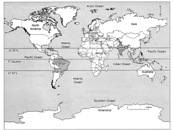
According to the equator, in which hemisphere is Brazil located?
Solution & Step-by-Step Answer:
Some part of Brazil lies in the northern hemisphere, while most of it lies in the southern hemisphere.
Question 17
Maharashtra Board Solution
In which hemispheres is India located?
Solution & Step-by-Step Answer:
India is located in the northern and eastern hemispheres.
Question 18
Maharashtra Board Solution
What type of government does Brazil have today?
Solution & Step-by-Step Answer:
Today, Brazil has Federal Presidential Republic type of government.
Question 19
Maharashtra Board Solution
What type of government does India have today?
Solution & Step-by-Step Answer:
Today, India has Federal Parliamentary Republic type of government.
Question 20
Maharashtra Board Solution
Where does the name Brazil come from?
Solution & Step-by-Step Answer:
The name Brazil comes from ‘Pau Brasil’, a local wooded tree.
Question 21
Maharashtra Board Solution
Who established the early settlement in Brazil?
Solution & Step-by-Step Answer:
The Portuguese settlers established the early settlement in Brazil.
Question 22
Maharashtra Board Solution
Distinguish between: Location of India and Brazil
Solution & Step-by-Step Answer:
Question 23
Maharashtra Board Solution
Find the difference between the post-independence characteristics of India and Brazil.
Solution & Step-by-Step Answer:
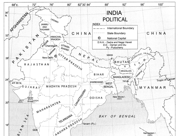
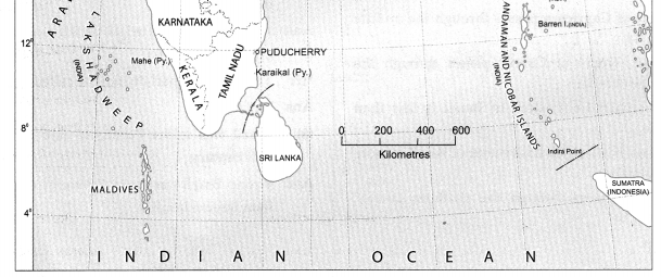
Observe the map and answer the following questions.
Question 1
Maharashtra Board Solution
Identify the countries and water bodies around India and complete the following table. To the North To the East To the South To the West
Solution & Step-by-Step Answer:
Question 2
Maharashtra Board Solution
Identify Brazil’s neighbouring countries and oceans. Complete the following table. (a) To the North (b) To the South (c) To the East (d) To the West
Solution & Step-by-Step Answer:
Question 3
Maharashtra Board Solution
Show the following on an outline of the world map. (a) Name all the continents and oceans of the world. (b) Colour Brazil and India using different colours and name them. (c) Draw equator on the map and write its value in degrees. (d) Show the symbol for direction.
Solution & Step-by-Step Answer:
Give geographical reasons:
Question 1
Maharashtra Board Solution
Brazil is called the ‘coffee pot of the world’.
Solution & Step-by-Step Answer:
(i) Brazil ranks first in the world in the terms of production of coffee. (ii) It produces nearly 40% of the total coffee production in the world. (iii) It is the largest exporter of coffee. Therefore, Brazil is called the ‘coffee pot of the world’.
Question 2
Maharashtra Board Solution
Brazil is known as the country having third longest land border.
Solution & Step-by-Step Answer:
(i) Brazil has the world’s third longest land border, after China and Russia. (ii) It shares its boundaries with all South American countries, except Chile and Ecuador, totalling 16,885 Kilometers. (iii) Brazil has borders with 10 different countries, which are Argentina, Bolivia, Colombia, French Guiana, Guyana, Paraguay, Peru, Suriname, Uruguay and Venezuela. (iv) Hence, Brazil is called the country having third longest land borders.
Question 3
Maharashtra Board Solution
India is looked upon as a young country.
Solution & Step-by-Step Answer:
(i) The proportion of youth in India’s population is high. (ii) This forms a major part of the working population. (iii) According to 2011 census the percentage of working population is more than 50 %. (iv) Hence, India is looked upon as a young country.
Question 4
Maharashtra Board Solution
India’s economic development has paced up. OR India is considered as a major global market.
Solution & Step-by-Step Answer:
(i) Despite facing several problems after independence, today India is a major developing country of the world. (ii) It is because of various reforms from time to time, that India’s economic development has paced up. (iii) So, it is considered to be a global market.
Answer in brief:
Question 1
Maharashtra Board Solution
What problems did Brazil and India face after independence?
Solution & Step-by-Step Answer:
(i) India was under the British rule for almost one-and-a-half centuries and it got its independence in the year 1947. (ii) It faced several problems like three wars, famine situations in various parts and similar issues after independence. (iii) Brazil gained its independence in 1822 after more than three centuries of Portuguese rule. (iv) From 1930 to 1985, for more than a half century, it was under a populist military government and it faced global financial difficulties in the late 20th century. Thus, both India and Brazil faced many problems post-independence.
Question 2
Maharashtra Board Solution
How are Brazil and India different from each other in terms of location?
Solution & Step-by-Step Answer:
(i) India is located in the northern hemisphere of the earth whereas some part of Brazil lies in the northern hemisphere and most of it lies in the southern hemisphere. (ii) India entirely lies in the eastern hemisphere whereas, Brazil lies in the western hemisphere. (iii) India lies in the continent of Asia whereas Brazil lies in the continent of South America. (iv) India lies in the southern part of the continent of Asia whereas Brazil lies in the northern part of South American continent.
Question 3
Maharashtra Board Solution
Describe the latitudinal and longitudinal extent of India and Brazil.
Solution & Step-by-Step Answer:
(i) The extent of the mainland India is 8°4’N to 37°6’N latitudes and between 68°7’E to 97°25’E longitudes. (ii) Indira Point is the southernmost tip of India. (iii) It is located on 6°45’N parallel. (iv) The extent of the mainland Brazil is 5°15’N to 33°45′ S latitudes and between to 34°47’W to 73°48’W longitude.
Class 10 Geography Chapter 2 Location and Extent Additional Important Questions and Answers Name the following:
Question 2
Maharashtra Board Solution
The country is famous for its spices in the world.
Solution & Step-by-Step Answer:
India
Question 3
Maharashtra Board Solution
The country is known as the ‘coffee pot’ of the world.
Solution & Step-by-Step Answer:
Brazil
Question 4
Maharashtra Board Solution
The famous dance form of Brazil.
Solution & Step-by-Step Answer:
Samba
Question 5
Maharashtra Board Solution
Hemispheres in which India is located.
Solution & Step-by-Step Answer:
Northern and eastern hemispheres.
Question 6
Maharashtra Board Solution
A continent in which India is located.
Solution & Step-by-Step Answer:
Asia
Question 7
Maharashtra Board Solution
The latitudinal extent of India.
Solution & Step-by-Step Answer:
8°4’N to 37°6’N
Question 8
Maharashtra Board Solution
The longitudinal extent of India.
Solution & Step-by-Step Answer:
68°7’E to 97°25’E
Question 8
Maharashtra Board Solution
Foreign power which ruled Brazil for more than three centuries.
Solution & Step-by-Step Answer:
Portuguese.
Question 9
Maharashtra Board Solution
Independence day of Brazil.
Solution & Step-by-Step Answer:
7th September 1822.
Question 10
Maharashtra Board Solution
Type of Government in Brazil from 1930 to 1985.
Solution & Step-by-Step Answer:
Populist Military Government.
Question 11
Maharashtra Board Solution
The latitudinal extent of Brazil.
Solution & Step-by-Step Answer:
5°15’N to 33°45’S.
Question 12
Maharashtra Board Solution
The longitudinal extent of Brazil.
Solution & Step-by-Step Answer:
34°47’W to 73°48’W
Choose the correct option and rewrite the statements:
Question 1
Maharashtra Board Solution
The second largest populated country in the world is _________. (a) China (b) Brazil (c) India (d) Russia
Solution & Step-by-Step Answer:
(c) India
Question 2
Maharashtra Board Solution
Brazil is famous for ________ type of dance form. (a) Salsa (b) Samba (c) Ballet (d) Tango
Solution & Step-by-Step Answer:
(b) Samba
Question 3
Maharashtra Board Solution
The country known as the ‘coffee pot’ of the world is _______. (a) Brazil (b) India (c) China (d) Pakistan
Solution & Step-by-Step Answer:
(a) Brazil
Question 4
Maharashtra Board Solution
India is located in the ________ part of the Asian continent. (a) southern (b) northern (c) northeastern (d) western
Solution & Step-by-Step Answer:
(a) southern
Question 5
Maharashtra Board Solution
Brazil gained independence in _______. (a) 1890 (b) 1980 (c) 1822 (d) 1820
Solution & Step-by-Step Answer:
(c) 1822
Question 6
Maharashtra Board Solution
Capital of Brazil is _______. (a) Kabul (b) Kaula Lumpur (c) Brasilia (d) Monaco
Solution & Step-by-Step Answer:
(c) Brasilia
Question 7
Maharashtra Board Solution
Capital of India is _____. (a) Patna (b) New Delhi (c) Dispur (d) Chandigarh
Solution & Step-by-Step Answer:
(b) New Delhi
Question 8
Maharashtra Board Solution
India was under ___ rule for almost one and a half-century. (a) Portuguese (b) African (c) Russian (d) British
Solution & Step-by-Step Answer:
(d) British
Question 9
Maharashtra Board Solution
For more than a half-century, Brazil was under a _____ government. (a) Populist military (b) Monarchy (c) Constitutional government (d) Dictatorial (a) Populist military |
Question 10. Most part of the of mainland Brazil lies in the ______ hemisphere. (a) northern (b) southern (c) eastern (d) northwestern
Solution & Step-by-Step Answer:
(b) southern
Question 11
Maharashtra Board Solution
Brazil was ruled by ______ imperial power which also ruled a part of India. (a) Portuguese (b) British (c) Indonesia (d) Pakistan
Solution & Step-by-Step Answer:
(a) Portuguese
|