Maharashtra State Board Class 10 Geography Solutions Chapter 9 Tourism, Transport and Communication
Class 10 Geography Chapter 9 Tourism, Transport and Communication Textbook Questions and Answers
1. State whether right or wrong with reasons.
Question a.
The future of tourism is bright in India due to its natural diversity.
Answer:
Right.
Question b.
Tourism is an invisible trade.
Answer:
Right.
Question c.
The indicator of development in a country is the development of transport in that country.
Answer:
Right
Question d.
Brazil’s time is ahead of India’s time.
Answer:
Wrong
2. Answer in short:
Question a.
Which factors attract more tourists in Brazil?
Answer:
The factors which attract more tourists in Brazil are:
Question b.
What are the difficulties in the development of the railway system in Brazil’s internal areas?
Answer:
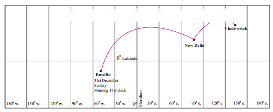
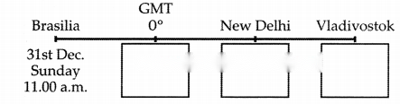
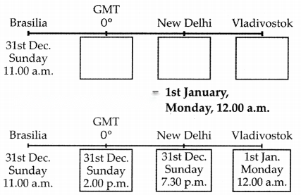
Time difference between GMT and New Delhi = 5 hours 30 min.
Time at New Delhi = 2 a.m. + 5 hours 30 min.
= 7 hours 30 min.
= 31st December,
Sunday, 7.30 p.m.
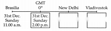
Time difference between
New Delhi and Vladivostok = 4 hours 30 min.
Time at Vladivostok = 7.30 p.m. + 4 hours 30 min.
= 12.00 am
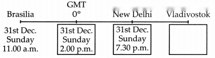
The local time, date and day at Delhi are 7 : 30p.m., 31st December, Sunday
local time, date and day at Vladivostok are 12 am., 1st January, Monday.
4. Match the following:
Column A’ | Column ’B’ |
(1) Trans-Amazonian | (a) Tourist Place Highway |
Answer:
1 – d
2 – c
3 – a
4 – b
5. Give geographical reasons:
Question a.
Eco-tourism is being developed more in Brazil.
Answer:
Question b.
The internal waterways are not developed in Brazil.
Answer:
Question c.
A dense network of railways has developed in the North Indian Plains.
Answer:
Question d.
Development of transport is important for the country’s progress.
Answer:
Question e.
We rely on the sea routes for international trade.
Answer:
6. Differentiate between:
Question a.
Water transport in the Amazon and the Ganga river.
Answer:
Water transport in the Amazon River | Water Transport in the Ganga River |
(i) River Amazon is navigable throughout its course due to its gentle slope. | (i) River Ganga is navigable only in its middle and lower course which is gentler as compared to its upper course. |
Question b.
Communication in Brazil and India
Answer:
Communication in Brazil | Communication in India |
(i) Telecommunication services in Brazil are well developed and efficient. | (i) With the explosion of electronic media, telecommunication industry has become one of the fast growing sectors. |
Question c.
IST and BRT
Answer:
IST | BRT |
(i) 1ST is the Indian Standard Time. | (i) BRT is the Brasilia Time/Brazil Time. (Standard Time) |
(ii) India has only one standard time zone. | (ii) Brazil has four time zones. |
(iii) The official 1ST is based on 82.5° E longitude | (iii) The official BRT is GMT – 03 which passes |
which passes through Allahabad, Uttar Pradesh. | through Brasilia. |
(iv) 1ST is 5hrs 30mins ahead of Greenwich Meridian | (iv) BRT is 2,3,4, or 5 hrs behind Greenwich Meridian |
(v) Time as India is in the eastern hemisphere. | (v) Time as Brazil is in the western hemisphere. |
7. Write short notes on:
Question a.
Modem means of communication:
Answer:
(i) Modern means of communication includes landlines as well as mobile services, television broadcasting and computer/internet access.
(ii) In this era of information and communication technology, digitally enhanced communication devices like mobile phones, smart phones, internet and satellites are being used.
Question b.
Air transport in India:
Answer:
(i) Air transport is more developed in India as compared to Brazil.
(ii) The use of international and internal airways is increasing.
(iii) Important airports from where domestic and foreign travel take place are Mumbai, Delhi, Kolkata, Chennai, Bengaluru, etc.
Question c.
Correlation between physiography and internal waterways:
Answer:
(i) Internal (Inland) waterways comprises of rivers, canals, backwaters, creeks, etc. which are the cheap means of transportation.
(ii) Deep waters, gentle slopes, absence of rapids and waterfalls and the long course of rivers are favourable factors for development of internal waterways.
(iii) The longest waterways in the world is developed in the Amazon river in Brazil which is navigable for around 3700 kms.
(iv) Perennial river like Ganga in India is navigable in its lower course but the peninsular rivers are not used due to shallow waters, shorter course, seasonal nature, etc.
Question d.
Importance of Standard Time:
Answer:
(i) Standard Time is the official time and is commonly accepted all over the country or region.
(ii) The importance of Standard Time is the most, if the country has a vast longitudinal extent, since there will be a great difference between the time of its places located in the eastern and the western parts.
(iii) It helps in making proper schedules of travel, business meeting, co-ordinating the functioning of various organisations, etc.
(iv) Thus Standard Time helps in avoiding confusion regarding day, date and time.
Class 10 Geography Chapter 9 Tourism, Transport and Communication Intext Questions and Answers
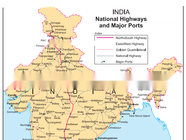
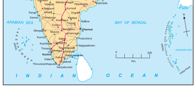
Answer the following questions on the basis of the map given.
Observe the map carefully and answer the following questions:
Question 1.
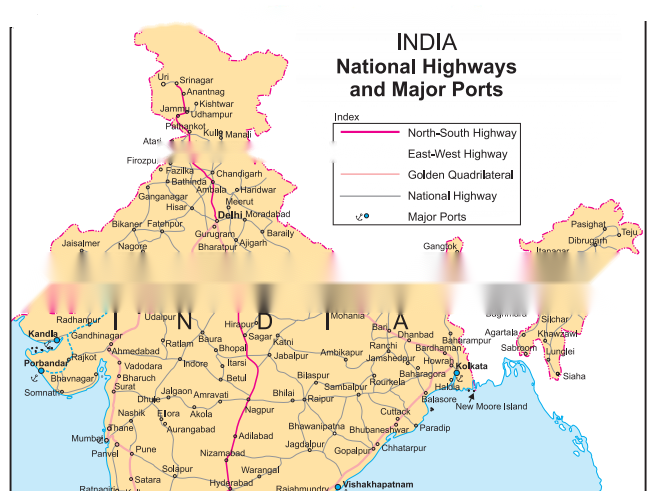
Name the terminal points of the North-South Corridor of Golden quadrilateral Highway.
Answer:
North – Srinagar, South – Kanyakumari.
Observe the given map carefully and answer the following questions:
Try this
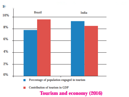
Look at the graph and answer the following questions:

Can you tell ?
Look at the graph and answer the following questions:
Make friends with maps
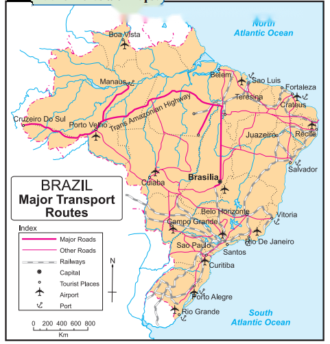
Study the transport map of Brazil and answer the following.
Think about it.
Activity
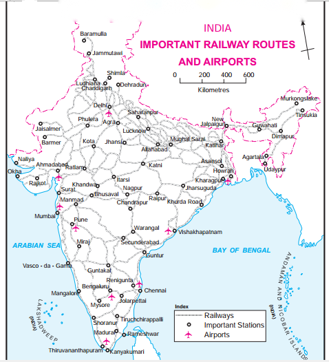
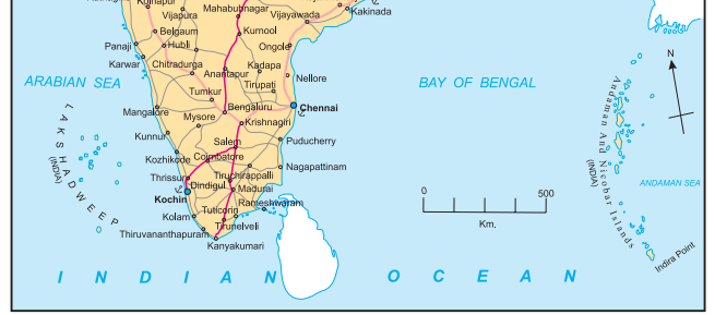
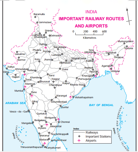
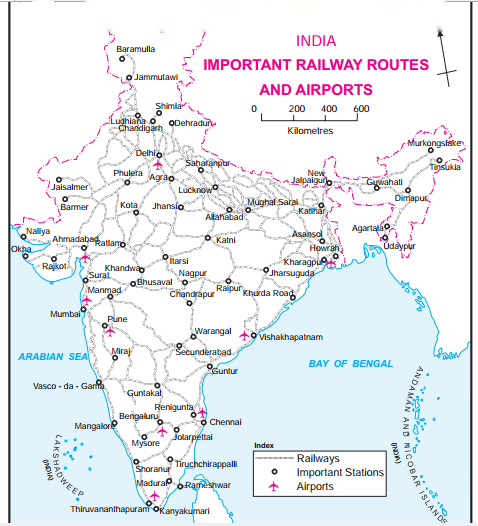
Look at the transport maps of India and the make friends with maps.
Give it a try.
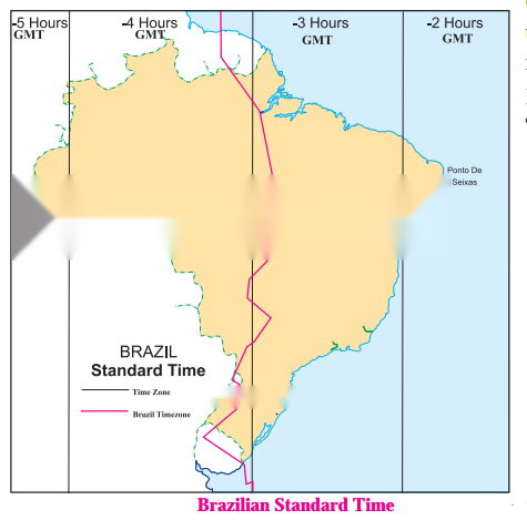
Westernmost point: Nascente do Rio Moa (07° 32’33″S, 70° 59’W) Easternmost point: Ponta do Seixas, Paraiba (07° 09′ 28″S, 34° 47’W),
The difference in time between the Easternmost and the Westernmost part of Brazil is 168 minutes.
Activity
Read the map and answer the following questions:
Question 1
Maharashtra Board Solution
How many divisions can you see in the map?
Solution & Step-by-Step Answer:
We can see 4 divisions in the map.
Question 2
Maharashtra Board Solution
What do these divisions signify?
Solution & Step-by-Step Answer:
These divisions signify the time zones in Brazil.
Question 3
Maharashtra Board Solution
What does the term ’behind the GMT’ mean?
Solution & Step-by-Step Answer:
The Greenwich Meridian Time is a time set with reference to 0° longitude that passes through Greenwich. The countries lying to the west of 0° longitude are ’behind the GMT’.
Question 4
Maharashtra Board Solution
Which part of Brazil is ahead of other?
Solution & Step-by-Step Answer:
The easternmost part of Brazil is ahead of the other parts.
Question 5
Maharashtra Board Solution
By how many minutes is this part ahead of others?
Solution & Step-by-Step Answer:
60 to 180 minutes.
Question 6
Maharashtra Board Solution
What does the red line in the map show?
Solution & Step-by-Step Answer:
The red line in the map is the official BRT which is in the GMT-03 time zone. It is 3 hours behind GMT.
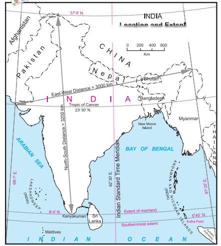
Make friends with maps Study the map given in figure and answer the following questions:
Question 1
Maharashtra Board Solution
Calculate the difference between the two longitudinal extremes of mainland India. Is it more than Brazil?
Solution & Step-by-Step Answer:
The difference between the two longitudinal extremes of east and west mainland India is about 29°.
Question 2
Maharashtra Board Solution
Which longitude in India is called the Indian Standard Time (IST)?
Solution & Step-by-Step Answer:
The 82° 30′ E longitude is called Indian Standard Time (IST)
Question 3
Maharashtra Board Solution
What is the difference between IST and the GMT?
Solution & Step-by-Step Answer:
The IST time is 5 hours and 30 minutes ahead of the GMT.
Question 4
Maharashtra Board Solution
How many local times are there in India?
Solution & Step-by-Step Answer:
There are 29 local times.
Question 5
Maharashtra Board Solution
How much is the time difference between the western most and the eastern most points of India?
Solution & Step-by-Step Answer:
Two hours, 120 minutes.
Think about it.
Question 1
Maharashtra Board Solution
It is 12 noon at Delhi. What would be the local time in Brasilia?
Solution & Step-by-Step Answer:
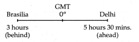
If it is 12 noon at Delhi, the local time in Brasilia would be 3.30 a.m. This is because Brasilia is 3 hours behind GMT and Delhi is 5 hours 30 minutes ahead of GMT. Therefore Time difference between Brasilia and Delhi is of 8 hours 30 mins (3 hours + 5 hours 30 mins) Time at Delhi = 12 noon Time at Brasilia = 12 noon – 8 hours 30 mins = 3.30 a.m.
Use your brain power
Question 1
Maharashtra Board Solution
Saurabh and Ashwini work for a MNC. Two of their regional head offices are located in Brazil in Rio De Janeiro and Manaus, respectively. Both of them have to contact either of the head offices constantly. As they have to adjust timings according to their head offices, find out their corresponding timings in India, if they work according to office timings in Brazil, i.e 10 a.m. to 5 p.m.
Solution & Step-by-Step Answer:
(i) Let us assume Saurabh is coordinating with Rio De Janeiro’s head office and Ashwini is coordinating with the head office of Manaus. (ii) Brazil has four time zones. It is behind the GMT by 2, 3, 4 or 5 hours. (iii) Rio De Janeiro is in the 2nd time zone which is 3 hours behind GMT (GMT-03) and Manaus is the 3rd time zone which is 4 hours behind GMT (GMT-04). (iv) Now, the time difference between GMT and 1ST is of 5 hours 30 mins. They have to make following adjustments :
Rio De Janeiro is in the 2nd time zone which is 3 hours behind GMT (GMT-03) and Manaus is the 3rd time zone which is 4 hours behind GMT (G Give it a try
Question 1
Maharashtra Board Solution
On what basis will you decide how many standard times should be there in a country?
Solution & Step-by-Step Answer:
The longitudinal extent of a country will help one decide how many standard times should be there in a country.
Class 10 Geography Chapter 9 Tourism, Transport and Communication Additional Important Questions and Answers Choose the correct option and rewrite the statements:
Question 1
Maharashtra Board Solution
The new capital city of Brazil is ______. (a) Rio de Janeiro (b) Sao Paulo (c) Manaus (d) Brasilia
Solution & Step-by-Step Answer:
(d) Brasilia
Question 2
Maharashtra Board Solution
A city that attracts a lot of tourists is _______. (a) Rio de Janeiro (b) Brasilia (c) Manaus (d) Ponta de Seixas
Solution & Step-by-Step Answer:
(a) Rio de Janeiro
Question 3
Maharashtra Board Solution
The proportion of the Indian population engaged in tourism is proportionately _____ Brazil. (a) lower than (b) higher than (c) equal to (d) extremely lesser than
Solution & Step-by-Step Answer:
(b) higher than
Question 4
Maharashtra Board Solution
The football stadium at ______ is quite well known (a) Rio de Janeiro (b) Manaus (c) Sao Paulo (d) Boa Vista
Solution & Step-by-Step Answer:
(b) Manaus
Question 5
Maharashtra Board Solution
The most common method of transportation in Brazil is ____. (a) railways (b) waterways (c) roadways (d) airways
Solution & Step-by-Step Answer:
(c) roadways
Question 6
Maharashtra Board Solution
The density of road network in Brazil is concentrated in the ____ part of the country. (a) southern (b) northern (c) western (d) eastern
Solution & Step-by-Step Answer:
(d) eastern
Question 7
Maharashtra Board Solution
The forested lands of the Amazon River basin and the ______ lands have limited the development of roadways in this part of Brazil. (a) drought-prone (b) fertile (c) swampy (d) semi-arid
Solution & Step-by-Step Answer:
(c) swampy
Question 8
Maharashtra Board Solution
Waterways have been developed on a commercial basis in the _____ river. (a) Amazon (b) Uruguay (c) Purus (d) Aragua
Solution & Step-by-Step Answer:
(a) Amazon
Question 9
Maharashtra Board Solution
Boats ply from _____ in Peru to the mouth of the river Amazon. (a) Lima (b) Cusco (c) Equitos (d) Nazca
Solution & Step-by-Step Answer:
(c) Equitos
Question 10
Maharashtra Board Solution
Apart from R. Amazon, another important river for waterways is the ____ Parana river. (a) south-flowing (b) north-flowing (c) east-flowing (d) west-flowing
Solution & Step-by-Step Answer:
(a) south-flowing
Question 11
Maharashtra Board Solution
The contribution of ______ is less in the transportation system of Brazil. (a) railways (b) roadways (c) waterways (d) airways
Solution & Step-by-Step Answer:
(d) airways
Question 12
Maharashtra Board Solution
Railway network is dense in the ______ of India. (a) hilly states (b) north-eastern states (c) central parts of India (d) north indian plains
Solution & Step-by-Step Answer:
(b) north-eastern states
Question 13
Maharashtra Board Solution
Approximately, 95% of foreign trade moves through ______ routes, in India. (a) road (b) rail (c) air (d) ocean
Solution & Step-by-Step Answer:
(d) ocean
Question 14
Maharashtra Board Solution
The westernmost extreme point on mainland Brazil is ______. (a) Rio Grande (b) Rio de Janeiro (c) Nascente do Rio Moa (d) Ponta do Seixas
Solution & Step-by-Step Answer:
(c) Nascente do Rio Moa
Question 15
Maharashtra Board Solution
The easternmost extreme point on mainland Brazil is ______ (a) Rio Grande (b) Sao Paulo (c) Ponta do Seixas (d) Nascente do Rio Moa
Solution & Step-by-Step Answer:
(c) Ponta do Seixas
Question 16
Maharashtra Board Solution
Brazil has ______ time zones. (a) 3 (b) 4 (c) 5 (d) 6
Solution & Step-by-Step Answer:
(b) 4
Question 17
Maharashtra Board Solution
(BRT) Brazil time is _____ hours behind GMT. (a) three (b) four (c) five (d) six
Solution & Step-by-Step Answer:
(a) three
Question 18
Maharashtra Board Solution
Today, more than 45% of the Brazilian population has access to the ______. (a) mobile services (b) television broadcasting (c) radio broadcasting (d) internet
Solution & Step-by-Step Answer:
(d) internet
Question 19
Maharashtra Board Solution
The telecommunication infrastructure is fairly modern, particularly in ____ Brazil. (a) north (b) north-west (c) north-east (d) central-south
Solution & Step-by-Step Answer:
(d) central-south
Question 20
Maharashtra Board Solution
______ services in Brazil are well-developed and efficient. (a) Air (b) Railway (c) Helicopter (d) Telecommunication
Solution & Step-by-Step Answer:
(d) Telecommunication
Question 21
Maharashtra Board Solution
With regard to telecommunication infrastructure, the north and ______ are drastically less developed. (a) south (b) south-west (c) north-west (d) central-south
Solution & Step-by-Step Answer:
(c) north-west
Question 22
Maharashtra Board Solution
Over recent years, _______ have led to the rapid expansion of telecommunication services in Brazil. (a) landline phones (b) radio broadcasting (c) television broadcasting (d) mobile telephones
Solution & Step-by-Step Answer:
(d) mobile telephones
Question 23
Maharashtra Board Solution
India has ______ standard time zone/s. (a) one (b) two (c) three (d) four
Solution & Step-by-Step Answer:
(a) one
Question 24
Maharashtra Board Solution
The difference between the two extreme most points in India is about _____. (a) 120 minutes (b) 210 minutes (c) 168 minutes (d) 186 minutes
Solution & Step-by-Step Answer:
(a) 120 minutes
Question 25
Maharashtra Board Solution
The difference between the two extreme most points of Brazil is _______. (a) 186 minutes (b) 168 minutes (c) 120 minutes (d) 200 minutes
Solution & Step-by-Step Answer:
(b) 168 minutes
Question 26
Maharashtra Board Solution
The 82°30’E longitude is the Indian Standard Time longitude which passes though ________. (a) Allahabad (b) Ahmedabad (c) Hyderabad (d) Muzzaffarabad
Solution & Step-by-Step Answer:
(a) Allahabad
Question 27
Maharashtra Board Solution
India is one of the largest users of _______ and internet. (a) landlines phones (b) television (c) radio (d) smartphones
Solution & Step-by-Step Answer:
(d) smartphones
Question 28
Maharashtra Board Solution
About 85% of passenger and 70% of freight traffic are carried by every year in India. (a) roadways (b) railways (c) waterways (d) airways
Solution & Step-by-Step Answer:
(a) roadways
Question 29
Maharashtra Board Solution
______is the official time of Brazil. (a) GMT-01 (b) GMT-04 (c) GMT-03 (d) GMT-02
Solution & Step-by-Step Answer:
(c) GMT-03
Question 30
Maharashtra Board Solution
The prominent highway of Brazil is ________. (a) Trans Belem Highway (b) Trans Rio Grande Highway (c) Trans Amazonian Highway (d) Trans Brasilia Highway
Solution & Step-by-Step Answer:
(c) Trans Amazonian Highway
Match the following:
Question 1
Maharashtra Board Solution
|
Column ’A’ | Column ‘B’ |
(1) The new capital city | (a) Rio de Janeiro |
(2) The city attracting a lot of tourist | (b) Manaus |
(3) Football stadium | (c) Peru |
(4) Beach | (d) Brasilia |
(5) Equitos | (e) Sao Paulo |
(f) Boa Vista |
1 – d
2 – e
3 – b
4 – a
5 – c
Answer the following questions in one sentence:
Question 1
Maharashtra Board Solution
State the factors that attract foreign tourists towards India.
Solution & Step-by-Step Answer:
Foreign tourists visit India to see and understand its rich heritage and culture, for adventure, to avail the health services and for business purposes.
Question 2
Maharashtra Board Solution
What is the kind of service provided by roadways in India?
Solution & Step-by-Step Answer:
About 85% of passenger traffic and 70% of freight traffic are carried by roadways every year in India.
Question 3
Maharashtra Board Solution
How important are the inland waterways in India’s transportation?
Solution & Step-by-Step Answer:
Inland waterways comprising rivers, canals, backwaters, creeks, etc., which contribute about only 1% to India’s transportation.
Question 4
Maharashtra Board Solution
In what way are the ocean routes useful for India?
Solution & Step-by-Step Answer:
Approximately 95% of India’s foreign trade moves through ocean routes.
Question 5
Maharashtra Board Solution
What kind of advanced space technology is Brazil developing?
Solution & Step-by-Step Answer:
Brazil is developing technology to send domestically-made satellites into space with its own rockets.
Question 6
Maharashtra Board Solution
Write a short note about the telecommunication infrastructure in different parts of Brazil.
Solution & Step-by-Step Answer:
The telecommunication infrastructure is fairly modern, particularly in central-south Brazil, but the north and north-west are drastically less developed.
Question 7
Maharashtra Board Solution
Why have roadways not developed in the north and north-western part?
Solution & Step-by-Step Answer:
The forested lands of the Amazon River basin and the swampy lands have limited the development of roadways in the north and north-western region.
Question 8
Maharashtra Board Solution
Which time zone is considered to be the official Brazilian time?
Solution & Step-by-Step Answer:
GMT-03 Time Zone is considered to be the official Brazilian time.
Distinguish between:
Question 1
Maharashtra Board Solution
The use of railways in Brazil and India.
Solution & Step-by-Step Answer:
Question 2
Maharashtra Board Solution
The longitudinal extent of India and Brazil
Solution & Step-by-Step Answer:
Question 3
Maharashtra Board Solution
The density of roadways in Brazil and India.
Solution & Step-by-Step Answer:
Question 1
Maharashtra Board Solution
Mark the following on an outline map of Brazil. Name the following: |
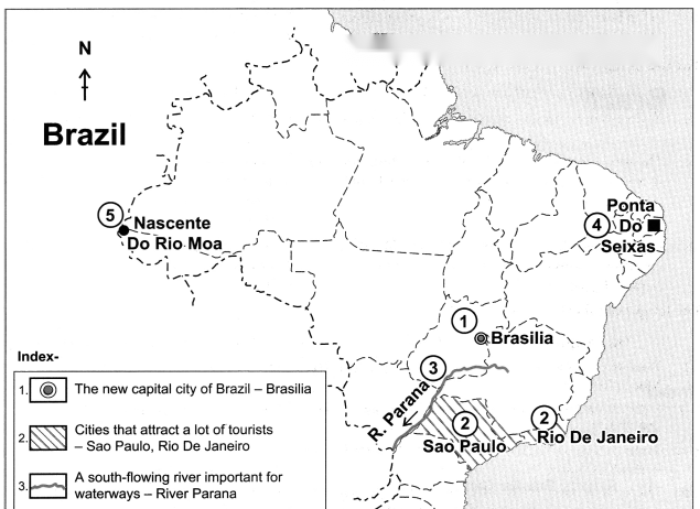

Question 2
Maharashtra Board Solution
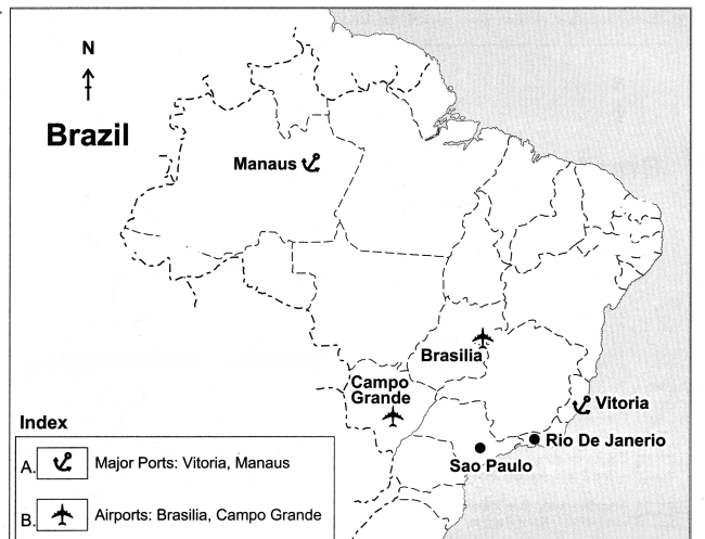
Show the following on a given outline map of Brazil. Given index:
(A) Ports: (B) Airports: (C) Railway Junctions:
Solution & Step-by-Step Answer:
Question 3
Maharashtra Board Solution
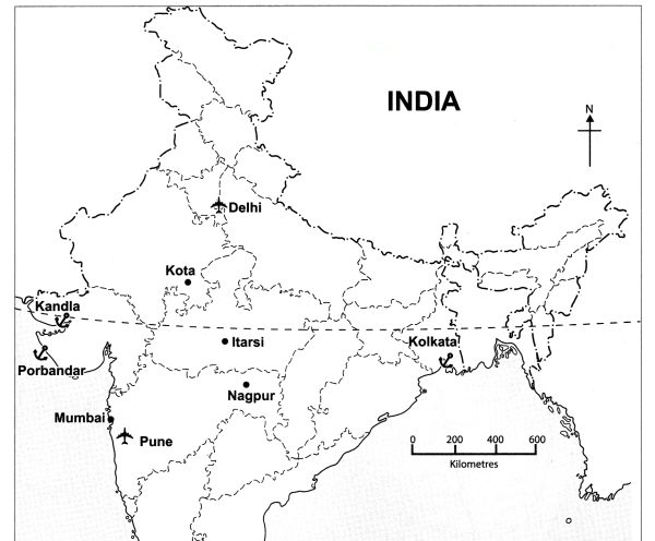
Show the following on a given outline map of India. Give index: Given index: (A) Ports: |

(B) Airports :
(C) Railway Junctions :
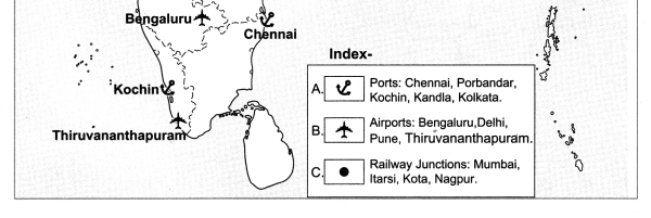
Give geographical reasons:
Question 1. India’s contribution of tourism to its GDP appears lesser than Brazil and population engaged seems higher. Answer: (i) The number of international tourists visiting India in 2015 was more than that of Brazil. (ii) Even though this is true, the share of tourism sector in the GDP is less than that of Brazil. (iii) Apart from this, the proportion of Indian population engaged in tourism is higher than that of Brazil. (iv) This is primarily dependent on the size of the population of those countries and the size of the GDP. (v) According to the data available, the population of India is more than Brazil and so is its GDP. (vi) As the GDP of India is higher than Brazil’s GDP to GDP appears lesser than Brazil’s and population engaged seems higher.
Question 2
Maharashtra Board Solution
Railways are important for the growth of the Indian economy.
Solution & Step-by-Step Answer:
(i) Railways are very important for a vast country like India where the distance between places is long. (ii) Freight and passenger transport have been facilitated due to the development of the railways. (iii) The more the facilities available for passenger transport and freight transport, the more growth in the economy. Thus, the railways are very important for the Indian economy’s growth.
Question 3
Maharashtra Board Solution
Brazil’s time is not ahead of India’s time.
Solution & Step-by-Step Answer:
(i) The GMT i.e, Greenwich Mean Time, divides the globe into eastern and western hemisphere. (ii) India lies to the east of GMT and Brazil lies to the West of GMT. (iii) Places lying to the east of GMT, are ahead of time and places lying to the west of GMT (like Brazil) are behind time.
Question 4
Maharashtra Board Solution
The future of tourism is bright in India.
Solution & Step-by-Step Answer:
(i) India is rich in natural beauty that includes mountains, forests, plateaus, plains, islands, coastal areas, beaches, etc. (ii) India also has a rich heritage and a huge variety of cultural and historical attractions. (iii) In recent years new forms of tourism have been developed in India like Eco tourism, Agro tourism, Medical tourism, Film tourism, etc. (iv) Also infrastructural facilities, branding and marketing initiatives have helped to promote Indian tourism. So the future of tourism is bright in India.
Question 5
Maharashtra Board Solution
Tourism is an invisible trade.
Solution & Step-by-Step Answer:
(i) Tourism belongs to the service sector as various services are provided to the tourists. (ii) For e.g., hotels, lodges, transport, food, entertainment, etc. (iii) Tourism increase the GDP of economy without exchange of goods. Thus, tourism is an invisible trade.
Question 6
Maharashtra Board Solution
he indicator of development in a country is the development of transport in that country.
Solution & Step-by-Step Answer:
(i) Transportation facilitates trade and creates employment opportunities. (ii) With the development of transport there is socio-economic and cultural development of the country. Hence it is an indicator of development in a country.
|