Maharashtra State Board Class 11 Geography Solutions Chapter 7 Indian Ocean – Relief and Strategic Importance
1. Complete the chain.
A | B | C |
(1) Pacific Ocean | (1) Christmas | (1) Bab-al-Mandeb |
(2) Chagos | (2) Atlantic Ocean | (2) Lakshadweep |
(3) Ashmore | (3) Maldives | (3) Indian Ocean |
(4) Hormuz | (4) Malacca | (4) Cocos |
A | B | C |
(1) Pacific Ocean | (1) Atlantic Ocean | (1) Indian Ocean |
(2) Chagos | (2) Christmas | (2) Lakshadweep |
(3) Ashmore | (3) Maldives | (3) Cocos |
(4) Hormuz | (4) Malacca | (4) Bab-al-Mandeb 2. Give geographical reasons.
Question 1
Maharashtra Board Solution
Salinity is less in the Bay of Bengal than in the Indian Ocean.
Solution & Step-by-Step Answer:
Salinity is less in the Bay of Bengal than in the Indian Ocean because-
Question 2
Maharashtra Board Solution
The eastern coastal part of the Indian Ocean is seismically active.
Solution & Step-by-Step Answer:
The eastern coastal part of the Indian Ocean is seismically active because-
Question 3
Maharashtra Board Solution
Gyre develops in Southern Indian Ocean.
Solution & Step-by-Step Answer:
Gyre develops in Southern Indian Ocean because-
Question 4
Maharashtra Board Solution
Temperatures are high in pre-monsoon season in the equatorial region in northern Indian Ocean.
Solution & Step-by-Step Answer:
3. Write short notes on.
Question 1
Maharashtra Board Solution
The width of continental shelf in the Bay of Bengal and the Arabian Sea
Solution & Step-by-Step Answer:
The continental shelf in the Bay of Bengal is narrow but the continental shelf in the Arabian sea is very wide.
The river which bring sediments to the continental shelf of the Arabian Sea are short and swift. Therefore, the sediments in the river are deposited in the Continental shelf. The rivers which bring sediments to the continental shelf of the Bay of Bengal are long, sluggish and voluminous, therefore sediments are deposited in deltas and not in the continental shelf. There are a greater number of estuaries along the coastline of Arabian sea. There are a greater number of deltas along the coastline of the Bay of Bengal.
Question 2
Maharashtra Board Solution
Mineral resources in the Indian Ocean
Solution & Step-by-Step Answer:
There are large reserves of hydrocarbons being tapped in the offshore areas of Saudi Arabia, Iran, India and Western Australia. About 40% of the world’s offshore oil production comes from the Indian Ocean.
The beach sands along the coastline of the Arabian Sea is very rich in valuable minerals like uranium, thorium, radium, etc. Beach sands, rich in heavy minerals and offshore deposits are activity exploited by bordering countries particularly India, South Africa, Indonesia and Sri Lanka. The Abyssal plains of Indian ocean have deposits of polymetallic nodules. These nodules are the source of nickel, copper, manganese and cobalt.
Question 3
Maharashtra Board Solution
Ocean Currents in the Indian Ocean.
Solution & Step-by-Step Answer:
Question 4
Maharashtra Board Solution
Oil and natural gas in the Indian Ocean
Solution & Step-by-Step Answer:
4. Answer in detail.
Question 1
Maharashtra Board Solution
Outline the importance of the Indian Ocean with respect to trade and transport routes.
Solution & Step-by-Step Answer:
Question 2
Maharashtra Board Solution
Evaluate the strategic location of India with respect to its location in the Indian Ocean.
Solution & Step-by-Step Answer:
Question 3
Maharashtra Board Solution
Explain the Indian ocean with respect to following aspects: (a) Ocean Trenches (b) Abyssal Plains (c) ridges (d) Ocean Currents
Solution & Step-by-Step Answer:
(a) Ocean Trenches
(b) Abyssal Plains: (c) Ridges: (d) Ocean Currents: 5. On an outline map of the world, locate the following and make an index: 1. Sunda Trench
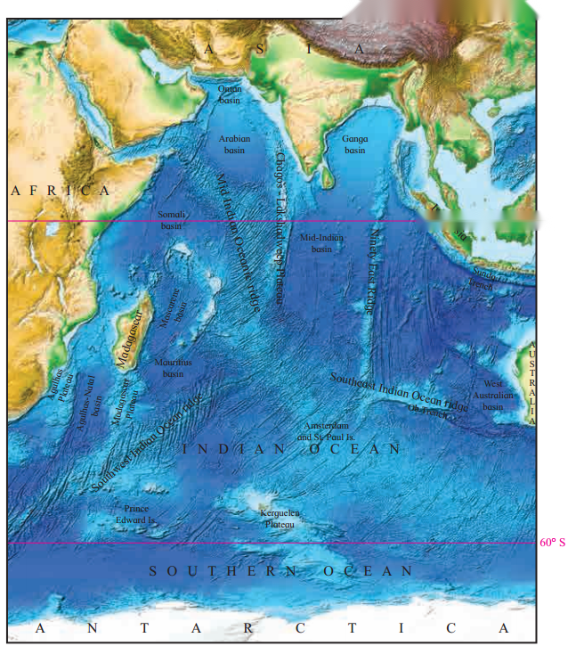
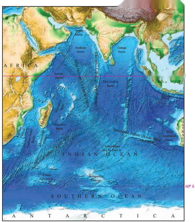
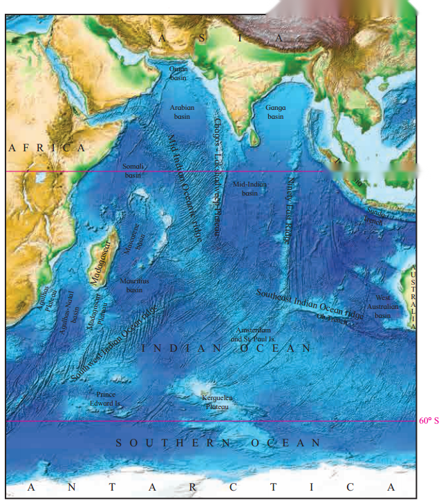
11th Geography Digest Chapter 7 Indian Ocean – Relief and Strategic Importance Intext Questions and Answers Make friends with maps! (Textbook Page No. 75) Look at the figure 7.1 and answer the following questions.
Question 1
Maharashtra Board Solution
What does this map show?
Solution & Step-by-Step Answer:
This map shows the relief of the Indian Ocean floor.
Question 2
Maharashtra Board Solution
Which continents and sub-continents are visible in this map?
Solution & Step-by-Step Answer:
The continents of Africa, Antarctica, Australia and the Indian sub-continent are visible in the map.
Question 3
Maharashtra Board Solution
What lies between the continents?
Solution & Step-by-Step Answer:
The Indian Ocean and the Southern Ocean lie between the continents.
Question 4
Maharashtra Board Solution
Chagos Plateau, Sunda Trench, Central Mountain range are a part of what?
Solution & Step-by-Step Answer:
The Chagos plateau is a part of Lakshadweep Plateau. The Sunda Trench is a part of the Java Trench located in the Indian Ocean near Sumatra, formed where Australian – Capricorn Plates subduct under a part of the Eurasian Plate. The central Mountain Range is a part of Mid Indian Oceanic ridge.
Question 5
Maharashtra Board Solution
What are the conclusions you can draw after looking at the map?
Solution & Step-by-Step Answer:
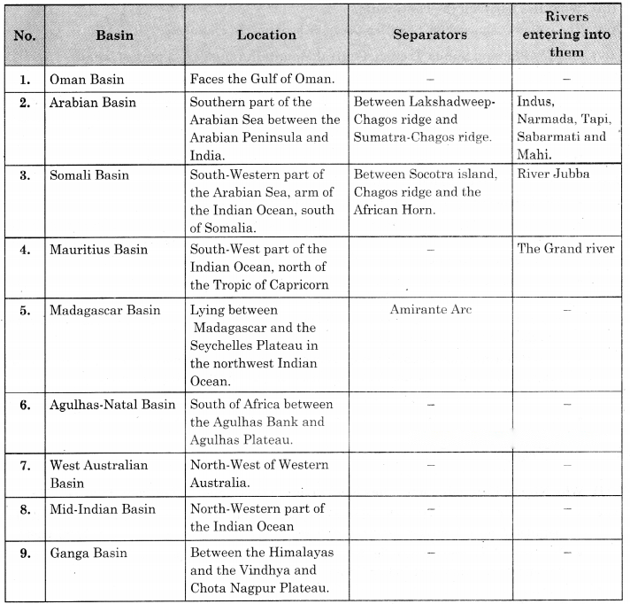
Find Out! (Textbook Page No. 77) Why Ninety East ridge name has been given to this ridge? Try This. (Textbook Page No. 78) Given below are names of some ocean basins in the Indian Ocean. Identify these in figure 7.1. Write a note on their locations, their separators and the rivers entering into them. Rank these according to their size on the basis of your perception.
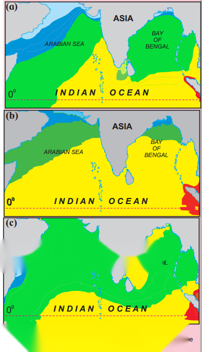
Can you do it? 1. Study maps given in the figure 7.2 carefully. These maps are showing the portion of Indian Ocean lying north of equator. Maps in the figure depict the temperature conditions in three seasons: (a) pre-SW monsoon (b) NE monsoon (c) during SW monsoon. Answer the following questions. (Textbook Page No. 78)
Question 1
Maharashtra Board Solution
Why are isotherms not drawn on the continental part?
Solution & Step-by-Step Answer:
The isotherms are not drawn on the continental part because there is summer season and the temperature is high almost everywhere. Since there is no variation in temperature, isotherms are not drawn.
Question 2
Maharashtra Board Solution
Why is the temperature low in Arabian Sea than in Bay of Bengal?
Solution & Step-by-Step Answer:
The temperature is low in Arabian Sea than in Bay of Bengal due to following reasons-
Question 3
Maharashtra Board Solution
Why is the temperature higher in southern portion of Indian Ocean during pre-SW monsoon?
Solution & Step-by-Step Answer:
The southern portion of the Indian Ocean is closer to the equator compared to the northern portion of the Arabian Sea. During pre-SW monsoon period, Uttarayan is observed therefore the temperature is high.
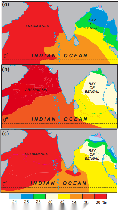
2. The given maps are depicting the salinity distribution of northern Indian Ocean. Study the maps (a) NE monsoon (b) pre-SW monsoon (c) SW monsoon given in the figure 7.3 carefully and answer the following questions. (Textbook Page No. 79)
Question 1
Maharashtra Board Solution
Why does the Arabian Sea record higher salinity than the Bay of Bengal?
Solution & Step-by-Step Answer:
This leads to higher salinity in the Arabian Sea as compared to the salinity of the Bay of Bengal.
Question 2
Maharashtra Board Solution
What is the minimum salinity in the Bay of Bengal? In Which seasons do we find it?
Solution & Step-by-Step Answer:
The minimum salinity in the Bay of Bengal is 30 PSU (Practical Salinity Unit). This occurs in the late autumn and early winter months (November to January) when the East India Coastal Current flows southwards carrying low salinity water.
Question 3
Maharashtra Board Solution
Account for the high salinity in the Arabian Sea throughout the year?
Solution & Step-by-Step Answer:
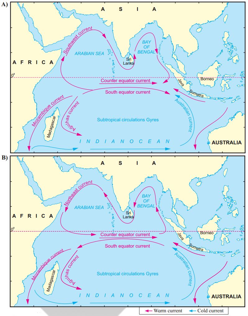
This leads to higher salinity in the Arabian Sea as compared to the salinity of the Bay of Bengal. Do you know? (Textbook Page No. 80) See the maps in figure 7.4 A and B. They show the pattern of ocean currents in the Indian Ocean during different seasons. Study the maps carefully and answer the following questions.
Question 1
Maharashtra Board Solution
Identify the season each map is representing and name them accordingly.
Solution & Step-by-Step Answer:
Question 2
Maharashtra Board Solution
What difference do you notice in the direction of currents between winter and summer in Northern Part of the Indian Ocean?
Solution & Step-by-Step Answer:
In the Northern Part of the Indian Ocean, during summer, the ocean currents flow along the coastlines and flow in the clockwise direction. In the winter season, these ocean currents flow a complete reverse and they flow in anticlockwise directions.
Question 3
Maharashtra Board Solution
How many cold currents are there in the Indian Ocean? Name them.
Solution & Step-by-Step Answer:
There are four cold currents in the Indian Ocean. The cold currents in the Indian Ocean are the North-East Monsoon Current, Somali Current, West Australian Current and South Indian Ocean Current.
Question 4
Maharashtra Board Solution
Why do you think the cold currents are fewer in Indian Ocean?
Solution & Step-by-Step Answer:
Question 5
Maharashtra Board Solution
Which currents maintain the direction in both the seasons?
Solution & Step-by-Step Answer:
The Mozambique Current, The Equatorial Counter Current, the Agulhas Current and the Australian Current maintain the direction in both the seasons.
Question 6
Maharashtra Board Solution
Can you see any circulation in the currents of the Indian Ocean? What are such circulations called? If yes, name the currents sequentially.
Solution & Step-by-Step Answer:
Yes, such circulations are currents called gyre.
Can you tell? (Textbook Page No. 81) (i) Name the Gulf countries |