Maharashtra State Board Class 5 EVS Solutions Part 1 Chapter 9 Maps – Our Companions
5th Std EVS 1 Digest Chapter 9 Maps – Our Companions Textbook Questions and Answers
1.Make a list of the various landforms in your surroundings. Draw one of the landforms in your notebook using one of the methods of showing landforms.
2. In the following sentences, underline the words that represent landform and prepare signs or symbols for them.
Question (a)
Sonali lives just beyond Mount Takmak.
Answer:
Mount (Δ)
Question (b)
Nilesh has gone on a trip to Gharapuri Island.
Answer:
Island
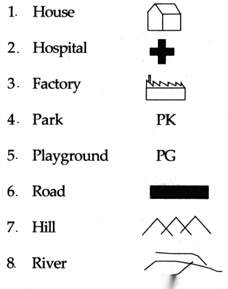
3. Prepare signs and symbols for the following components:
Solution & Step-by-Step Answer:
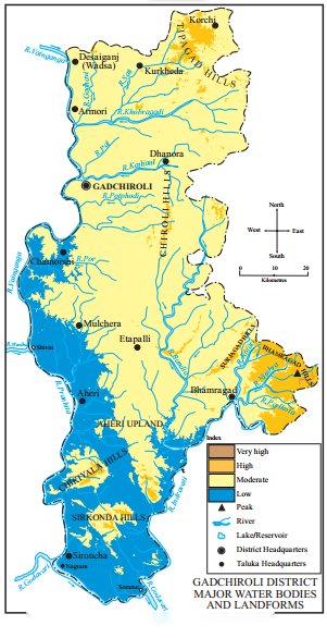
4.The given map shows height through the use of colours. However, one colour representation is wrong. Write which colour would be correct in its place.
Solution & Step-by-Step Answer:
In place of blue the colour for low elevation to be used should have been green.
Use your brain power!
Solution & Step-by-Step Answer:


Environmental Studies Part 1 Standard 5th Solutions Chapter 9 Maps – Our Companions Additional Important Questions and Answers
Fill in the blanks with the correct answers from the options given below:
Solution & Step-by-Step Answer:
(b) wars
Solution & Step-by-Step Answer:
(c) blue
Solution & Step-by-Step Answer:
(b) digital elevation
Solution & Step-by-Step Answer:
(a) Survey of India
Solution & Step-by-Step Answer:
(b) Dehradun
Solution & Step-by-Step Answer:
(c) 1767
Solution & Step-by-Step Answer:
(b) height
Solution & Step-by-Step Answer:
(a) land forms
Solution & Step-by-Step Answer:
(c) methods
Solution & Step-by-Step Answer:
(a) depth & (c) height
Solution & Step-by-Step Answer:
(c) sea-level
Solution & Step-by-Step Answer:
(a) steep
Solution & Step-by-Step Answer:
(b) gentle
Solution & Step-by-Step Answer:
(c) height
Solution & Step-by-Step Answer:
(a) information
Solution & Step-by-Step Answer:
(b) digital
Solution & Step-by-Step Answer:
(c) map
Solution & Step-by-Step Answer:
(a) symbols
2. Match the following:
Solution & Step-by-Step Answer:
1 – c, 2 – e, 3 – a, 4 – b, 5 – d

Answer in one sentence:
Solution & Step-by-Step Answer:
The different ways of showing elevation of land on a map are contour line method, layer tinting method and digital elevation method.
Solution & Step-by-Step Answer:
Lines on a map joining places having same height are called contour lines.
Solution & Step-by-Step Answer:
Digital elevation model is prepared with the information obtained through manmade satellites and help of computers.
Solution & Step-by-Step Answer:
Physical maps are used in military operations, tourism, drawing up mountaineering routes, in making regional development projects etc.
Solution & Step-by-Step Answer:
Conventional signs are down in the form of letters or geometrical shapes, for example, lines, circle, triangle, dots etc.
Solution & Step-by-Step Answer:
Conventional symbols are miniature drawings of the respective objects for eg, temples, mosque, forts etc.
Solution & Step-by-Step Answer:
Mountains, valleys, plateaus, plains and islands are different land forms.
Solution & Step-by-Step Answer:
During ancient times, maps were mainly used in wars.
Solution & Step-by-Step Answer:
The height of land is measured from sea-level.
Solution & Step-by-Step Answer:
Contour line method helps us to understand the slope of the land and the height of different places.
Solution & Step-by-Step Answer:
In layer tinting method, each colour indicates a specific height.
Solution & Step-by-Step Answer:
Standard signs and symbols are used to make the map easy to read.
Solution & Step-by-Step Answer:
The ‘Survey of India’ is the foremost mapmaking institute in India.
Solution & Step-by-Step Answer:
The topographic maps made by ‘Survey of India’ are known all over the world for their accuracy.
Give geographical reasons:
Solution & Step-by-Step Answer:
Answer in brief:
Solution & Step-by-Step Answer:
Solution & Step-by-Step Answer:
Use your brain power!
Solution & Step-by-Step Answer:
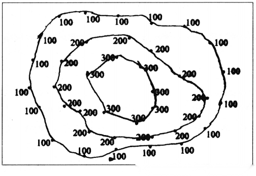
Contour line method.
Solution & Step-by-Step Answer:

Can you tell?
Solution & Step-by-Step Answer:
Lines which are called contours.
Solution & Step-by-Step Answer:
The colours between the contour lines shows the difference in the physical set up.
Solution & Step-by-Step Answer:
In map C we can directly observe the differences in the height of landforms.
Solution & Step-by-Step Answer:
South East
Solution & Step-by-Step Answer:
Map B.
Solution & Step-by-Step Answer:
Glossary: