Maharashtra State Board Class 11 Geography Solutions Chapter 3 Agents of Erosion
1. Compete the Chain.
Agent | Erosional/Depositional features | Places / Regions |
(1) River | (1) Caves | (1) China |
(2) Wind | (2) Beach | (2) Jog |
(3) Sea waves | (3) Waterfalls | (3) Meghalaya |
(4) Glaciers | (4) Loess | (4) Diveagar |
(5) Ground water | (5) Matterhorn | (5) Swiss Alps |
Agent | Erosional/Depositional features | Places / Regions | |||||||||||||||||||||||||||||||||||||||||||||||||||||||||||||
(1) River | (1) Waterfalls | (1) Jog | |||||||||||||||||||||||||||||||||||||||||||||||||||||||||||||
(2) Wind | (2) Loess | (2) China | |||||||||||||||||||||||||||||||||||||||||||||||||||||||||||||
(3) Sea waves | (3) Beach | (3) Diveagar | |||||||||||||||||||||||||||||||||||||||||||||||||||||||||||||
(4) Glaciers | (4) Matterhorn | (4) Swiss Alps | |||||||||||||||||||||||||||||||||||||||||||||||||||||||||||||
(5) Ground water | (5) Caves | (5) Meghalaya 2. Choose the correct option by identifying the correct correlation in the sentences.
Question 1
Maharashtra Board Solution
Water or snow enters the cracks in the rocks and makes it weak. When the glacier passes on these rocks, it pulls the rocks at the bottom along with it. This process is called (a) Plucking (b) Abrasion (c) Attrition (d) Transportation
Solution & Step-by-Step Answer:
(d) Transportation
Question 2
Maharashtra Board Solution
Sometimes, the river starts erosion upstream. This happens when the head stream gets a lot of water in the early stages of river’s flow. (a) Downcutting (b) Headward erosion (c) Lateral erosion (d) Vertical erosion
Solution & Step-by-Step Answer:
(b) Headward erosion
Question 3
Maharashtra Board Solution
Soft rock erodes beneath the hard rock due to sea waves. This results into landforms which further develop as sea arches. The landform is (a) Sea cave (b) Sea stack (c) Sea cliff (d) Wave cut platform
Solution & Step-by-Step Answer:
(a) Sea cave
Question 4
Maharashtra Board Solution
This landform develops due to depositional work of wind. The windward slope of this landform is gentle. (a) Loess plains (b) Barchans (c) Seif (d) Sand hills
Solution & Step-by-Step Answer:
(b) Barchans
Question 5
Maharashtra Board Solution
River, glacier, wind, sea waves and groundwater are the agents of erosion. Following work in the correct order is responsible to form various landforms. (a) Disintegration, picking up, transportation, weathering (b) Picking up, disintegration, deposition, weathering (c) Deposition, transportation, picking up, disintegration (d) Disintegration, picking up, transportation, deposition
Solution & Step-by-Step Answer:
(d) Disintegration, picking up, transportation, deposition
3. Give geographical reasons.
Question 1
Maharashtra Board Solution
The Eastern coast of India have deltas formed by the rivers but the Western coast has estuaries.
Solution & Step-by-Step Answer:
The Eastern coast of India have deltas formed by the rivers but the Western coast has estuaries because-
Question 2
Maharashtra Board Solution
There is direct relationship between the velocity of the agents and process of deposition.
Solution & Step-by-Step Answer:
There is direct relationship between the velocity of the agents and the process of deposition because-
Question 3
Maharashtra Board Solution
Compared to all the agents, sea waves work ceaselessly.
Solution & Step-by-Step Answer:
Compared to all the agents, sea waves work ceaselessly because-
Question 4
Maharashtra Board Solution
One finds many sheep rocks, horns, Aretes and hanging valleys in the Himalayas.
Solution & Step-by-Step Answer:
One finds many sheep rocks, horns, Aretes and hanging valleys in the Himalayas because- 1. In Himalayas work of glacier is more predominant due to snow covered peaks and slopes. Sheep rock, horns, Aretes and hanging valleys are formed by glacier. Like other agents of erosion, glaciers too carry out erosion, transportation and deposition.
2. In the Himalayas, glaciers remove rock particles from the surface on which they flow by abrasion which leads to formation of sheep rocks. 3. Ice movement, accompanied by weathering and mass wasting has steepened the walls at the head of the glacier. This has deepened into armchair-shaped depression called cirque. 4. In Himalayas, two of more cirques have developed and the area between them is narrowed and formed arete and further the headward erosion of the glaciers has eroded the summit leading to the formation of typical peak called horn. 5. The Himalayan glaciers too have tributaries like rivers. The rate of erosion is different. The main valley gets eroded faster and becomes deeper than the tributary glacial valley. These appear to be hanging when seen from the main valley. Thus, hanging valleys are formed.
Question 5
Maharashtra Board Solution
Karst landforms are seen concealed under the surface of the earth.
Solution & Step-by-Step Answer:
Karst landforms are seen concealed under the surface of the earth because-
Question 6
Maharashtra Board Solution
Snowline decides the limit of glacier work as an agent of erosion.
Solution & Step-by-Step Answer:
Snowline decides the limit of glacier work as an agent of erosion because-
4. Write short notes on.
Question 1
Maharashtra Board Solution
Attrition
Solution & Step-by-Step Answer:
Question 2
Maharashtra Board Solution
The work of rivers in hilly areas and human activities :
Solution & Step-by-Step Answer:
Gorges: River from its source, when it starts flowing the process of erosion starts. In mountainous areas, rivers flow at a higher speed due to steep slope. As a result, bed gets eroded more than banks and gorges are formed with steep banks and narrow beds. Such gorges have also become famous tourist places. For example, Gorge of Narmada river at Jabalpur.
In ‘V’ shaped valleys of river, terraced farming is practiced on valley slopes. In hilly areas, the river has speed, slope and hence downcutting is on a lower scale. Thus, agriculture, agroforestry, animal husbandry and forestry are the major human occupations in these regions. Waterfalls: Water flowing over a hilly region comes down a cliff, forming alternate bands of eroded soft and hard rocks, such features are called waterfalls. These waterfalls become a site for tourist attraction. For example, Jog falls on Sharavati river, Chuliya falls on Chambal river and Venna falls in Mahabaleshwar. Hotel industries also developed along these features.
Question 3
Maharashtra Board Solution
Conditions necessary for work of wind
Solution & Step-by-Step Answer:
Wind is a significant agent of erosion in the deserts. Following conditions are necessary for wind to become effective:
5. Differentiate between.
Question 1
Maharashtra Board Solution
Attrition and Abrasion.
Solution & Step-by-Step Answer:
Question 2
Maharashtra Board Solution
U shaped valley and V shaped valley.
Solution & Step-by-Step Answer:
Question 3
Maharashtra Board Solution
Stalactite and Stalagmite.
Solution & Step-by-Step Answer:
Question 4
Maharashtra Board Solution
Tributaries and Distributaries.
Solution & Step-by-Step Answer:
6. Answer in detail.
Question 1
Maharashtra Board Solution
Explain the landforms formed by different agents through the process of abrasion.
Solution & Step-by-Step Answer:
Abrasion involves the scratching and polishing of the surface or bedrock by the particles which are moving onto it. Let us study different landforms formed by different agents of erosion through the process of abrasion. Work of Seas Waves:
Work of Wind: (ii) Mushroom rocks (iii) Yardang: Work of Glaciers (ii) Cirque (iii) Arete (iv) Horn (v) U-Shaped Valleys
Question 2
Maharashtra Board Solution
Explain how the depositional work done by River Ganga has been beneficial to human activities.
Solution & Step-by-Step Answer:
The River Ganga and its tributaries have deposited load of sediments in the northern Ganga region. Features formed are: Alluvial Plain Region : The River Ganga and its tributaries bring loads of sediments – organic sediments like dead remains of plants and animals, skin, hide, bones etc., and inorganic sediments like sand, silt, clay, gravel, etc., and deposits at the foothills of the Himalayan family, Northern Ganga Plain region. It is a fertile land and agriculture is the major human occupation. Along with agriculture river transportation and fishing is also done on a large scale. Fertile plains are in Uttar Pradesh, Bihar, Punjab and Haryana.
Delta: Ganga-Brahmaputra delta, world’s largest delta has been formed at the mouth of the River Ganga. This delta is known as Sundarbans and is located in West Bengal. It is one of the most fertile regions in the world. Most delta is composed of alluvial soil. Thus, agriculture is the occupation followed in this region too.
Question 3
Maharashtra Board Solution
Which agents of erosion can you see on the cover page of the textbook? Which landforms can you see there? Write the process of formation of any one.
Solution & Step-by-Step Answer:
Every bend is made more and more pronounced by dashing of water on outer bank which gets eroded while inner banks have deposition. In due course of time they develop into circular loops, they are called meanders. 7. Draw neat and labelled diagrams for
Question 1
Maharashtra Board Solution
Deflation
Solution & Step-by-Step Answer:
Question 2
Maharashtra Board Solution
Wave-cut platform
Solution & Step-by-Step Answer:
Question 3
Maharashtra Board Solution
Mushroom rocks
Solution & Step-by-Step Answer:
11th Geography Digest Chapter 3 Agents of Erosion Intext Questions and Answers Can you tell? (Textbook Page No. 27) 1. The names of many places may have some relation with the landforms located there. The names of few of them are given below as example. You are expected to find out the particular landforms to which they are associated. Find about them and try to locate them on a map using an atlas. Make a list of similar examples from India.
Answer:
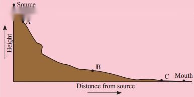
2. Look at the figure below and answer the questions. (Textbook Page No. 32)
Question 1
Maharashtra Board Solution
What features are formed in the upper course of the river? What processes will play an important role?
Solution & Step-by-Step Answer:
Features formed in the upper course of the river are V-shaped valleys, gorges and canyons, potholes, waterfalls and rapids. Processes responsible for the formation of these landforms are – downcutting, drilling.
Question 2
Maharashtra Board Solution
Can you mark the location where waterfall may form?
Solution & Step-by-Step Answer:
Waterfall may form at location ‘A’
Question 3
Maharashtra Board Solution
Why is there a change in slope from A to B? How will it influence the flow of the river?
Solution & Step-by-Step Answer:
There will be a change in slope from A to B when river enters the plains at the foothills of a mountain. The flow of the river decreases, the velocity reduces abruptly.
Question 4
Maharashtra Board Solution
Which human activities can be conducted in the region around A and B?
Solution & Step-by-Step Answer:
Around region A terraced farming can be practised. Around region B there is rich with alluvium brough down by the rivers, the plain is extensive and useful for agriculture. As the river widens around the source B, fishing and transportation is also found.
Question 5
Maharashtra Board Solution
In which area will the process of deposition overtake erosion?
Solution & Step-by-Step Answer:
Deposition will be found at B and C.
Question 6
Maharashtra Board Solution
Alluvial fans and deltas are both features formed due to deposition but at different locations. Identify their regions of formation and reason behind their different locations.
Solution & Step-by-Step Answer:
Alluvial fans will be formed at source ‘B’ at the foothills of the mountains, as there is change in slope and the velocity of the river reduces abruptly. Now the river is unable to carry heavy load. A delta will be formed at the mouth of the river. In this region, which is an extensively flat region, and where the sediments supply is high but velocity is low. So, the river deposits the sediments and branches out to meet ocean or sea.
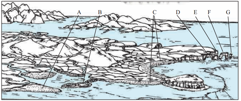
3. Look at the figure and identify landforms at A, B, C, D, E, F, G. (Textbook Page No. 34)
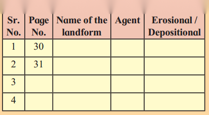
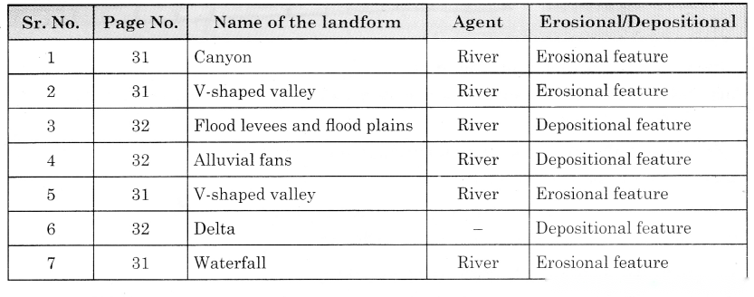
Let’s recall. (Textbook Page No. 30) You have already learnt about various landforms formed by the agents of erosion in Class IX. Identify the landforms given in class IX textbook from page no. 30 to 38. Identify the agent which is responsible for their formation. Also, state whether they are erosional or depositional landforms. Complete the table accordingly.
Think about it. (Textbook Page No. 30) Have you ever been to a river and seen its bed? Discuss in the class about your observation about the river, its banks, its bed and its velocity. Find out! (Textbook Page No. 31) Find out famous examples of gorges and canyons. 1. Study figure given below and answer the following questions. (Textbook Page No. 38)
Question 1
Maharashtra Board Solution
Which rocks are mainly found here?
Solution & Step-by-Step Answer:
Soluble rock like limestone, a sedimentary rock composed of Calcium Carbonate (CaCO3) are found.
Question 2
Maharashtra Board Solution
Identify the spot where stream disappears.
Solution & Step-by-Step Answer:
Steam will disappear below the sink hole.
Question 3
Maharashtra Board Solution
Which major erosional process works in this area?
Solution & Step-by-Step Answer:
Solution is the major erosional process in this area.
Question 4
Maharashtra Board Solution
Identify the landforms formed by deposition.
Solution & Step-by-Step Answer:
Stalactite, Stalagmite, columns or pillars are the landforms formed by deposition.
Question 5
Maharashtra Board Solution
Why do depositional landforms not form on the surface in areas of Karst terrain?
Solution & Step-by-Step Answer:
In Karst terrain groundwater dissolves minerals like calcium carbonate present in the rocks. The dripping water leaves behind a deposit of calcium carbonate. The water saturated with calcium carbonate dripping on the floor of a cave deposits calcium carbonate on the floor. Thus, depositional landforms do not form on the surface in the areas of Karst terrain.
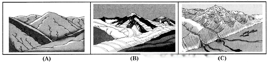
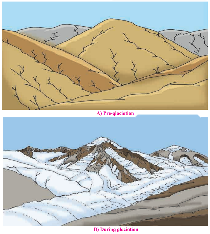
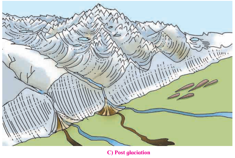
2. See the figure give below A, B, C. Answer the following questions. (Textbook Page No. 40) Img 8
Question 2
Maharashtra Board Solution
Identify the landforms formed due to erosion by glaciers.
Solution & Step-by-Step Answer:
Cirques, horn, U-shaped valleys, hanging valleys are formed due to erosion by glaciers.
Question 3
Maharashtra Board Solution
Where can U-Shaped valleys be formed?
Solution & Step-by-Step Answer:
U- Shaped valley is formed in the pre-existing valley.
Question 4
Maharashtra Board Solution
In which region will deposition occur?
Solution & Step-by-Step Answer:
Deposition starts generally along the side and front of ice.
Question 5
Maharashtra Board Solution
Identify the landforms formed by deposition by glaciers.
Solution & Step-by-Step Answer:
Drumlins, eskers, moraines are the depositional features formed by glaciers.
Use your brain power! (Textbook Page No. 41) In which diagram of the three will you find end moraines? See fig. 3.5 A, B, C.
|