Maharashtra State Board Class 11 Geography Solutions Chapter 4 Climatic Regions
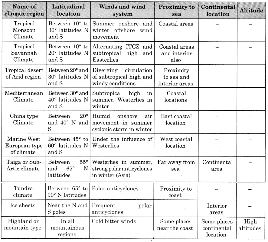
1. Write the names of climatic regions according to the factors that dominate their characteristics.
Answer:

2. Choose the correct alternative
(b) Average temperature in Summers around 35° C
< 2500 mm annual rainfall
South East Asia
Hard wood deciduous trees
(c) Temperatures in summer around 35° C
1000 mm annual rainfall
Continental part of Indian peninsula
Tall and thick grass
(d) Average temperatures in summer around 27° C
1000 mm rainfall in winter
South Africa
Hard–wooded, waxy, evergreen forests
(b) Average temperature in Summers around 35° C
< 2500 mm annual rainfall
South East Asia
Hard wood deciduous trees
Question 2
Maharashtra Board Solution
The region with high diurnal range of temperature (a) Tropical rainforests (b) Tropical grasslands (c) Tropical desert regions (d) Tropical Monsoon regions
Solution & Step-by-Step Answer:
(c) Tropical desert regions
Question 3
Maharashtra Board Solution
Lumbering flourished as an occupation from Newfoundland to Alaska in North America because (a) Tundra Climatic Region (b) Taiga Climatic Region (c) West European Climatic Region (d) China-type climatic region
Solution & Step-by-Step Answer:
(b) Taiga Climatic Region
Question 4
Maharashtra Board Solution
The main reason behind the months of precipitation in the graphs of Monsoon climatic regions being different is (a) ITCZ (b) orographic rainfall (c) hemispheres are different (d) apparent movement of the sun
Solution & Step-by-Step Answer:
(a) ITCZ
3. Give geographical reasons.
Question 1
Maharashtra Board Solution
In monsoon climate region, rainfall occurs in specific season.
Solution & Step-by-Step Answer:
In monsoon climate region, rainfall occurs in specific season because-
Question 2
Maharashtra Board Solution
Taiga region is not found in Southern Hemisphere.
Solution & Step-by-Step Answer:
Taiga region is not found in Southern Hemisphere because-
Question 3
Maharashtra Board Solution
The diurnal range of temperature is more in desert areas.
Solution & Step-by-Step Answer:
The diurnal range of temperature is more in desert areas because-
Question 4
Maharashtra Board Solution
There is no concept of season in equatorial regions.
Solution & Step-by-Step Answer:
There is no concept of season in equatorial regions because-
Question 5
Maharashtra Board Solution
The Savannah region is prone to droughts.
Solution & Step-by-Step Answer:
The Savannah region is prone to droughts because-
Question 6
Maharashtra Board Solution
Though Mussoorie and Dehradun are located on the same latitude, why is their climate different?
Solution & Step-by-Step Answer:
Though Mussoorie and Dehradun are located on the same latitude, their climate is different because-
4. Differentiate between.
Question 1
Maharashtra Board Solution
Equatorial Rainforests and Savannah Climatic Regions.
Solution & Step-by-Step Answer:
Question 2
Maharashtra Board Solution
Taiga Region and Tundra Region.
Solution & Step-by-Step Answer:
Question 3
Maharashtra Board Solution
Monsoon and Mediterranean Regions.
Solution & Step-by-Step Answer:
5. Answer in detail.
Question 1
Maharashtra Board Solution
Explain, with examples, the effects of latitude on a place’s climate.
Solution & Step-by-Step Answer:
Latitudes affect the climate of a place in different ways- Places close to the equator receive more sunlight:
Places close to the tropical region receives less sunlight:
Question 2
Maharashtra Board Solution
Explain with examples, how winds affect the climate of a place.
Solution & Step-by-Step Answer:
Question 3
Maharashtra Board Solution
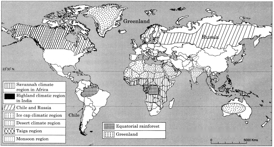
Russia is larger than Chile in area but does not experience climatic diversity as Chile. Explain.
Solution & Step-by-Step Answer:
Question 4
Maharashtra Board Solution
Explain the factors affecting climate of a place giving examples.
Solution & Step-by-Step Answer:
Latitude : Latitude is the primary factor influencing distribution of atmospheric temperature. Generally, latitudes of high degrees are less warm than the low degrees of latitudes. Thus, sun’s rays making a high angle to the ground, experience high temperature throughout the year. Temperature gradually decreases with increasing distance from the equator as the angle of the sun’s rays decreases away from it. Hence, the polar region experiences very low temperature.
Altitude : The atmosphere is indirectly heated by terrestrial radiation from surface of the earth. Therefore, the place near the sea level experiences higher temperature than the places situated at higher altitude. In other words, the temperature generally decreases with increase in height. The rate of decrease of temperature with increase in height is known as Normal Lapse rate. It is 6.4°C per 1000 meters altitude. Distance from the Sea : The location of place with respect to the sea also determines the temperature of that place. Though, the sun provides same amount of heat over land and water bodies, there is difference in their heating and cooling capacity. Compared to land, the sea (water) gets heated slowly and loses heat slowly. On the other hand, land heats up and cools down faster. Therefore, the variation in temperature over the water bodies is less as compared to land masses. The coastal areas come under the moderating influence of the sea and land breezes and experience moderate or equable climate while interior parts of the continents experience extreme climate. Prevailing winds : Winds affect the temperature and rainfall of any area. Winds carry with them the temperature of their source regions. Hot winds increase the temperature while cold winds decrease the temperature, e.g., cold wind waves from Himalayas carry low temperature to parts of the Deccan Plateau. Thus, south west monsoon winds in India reduce the temperature after the onset of monsoon in June all over the country. Some winds carry moisture and give rain to the area they visit. For example, South-west monsoon winds give rainfall to western coastline of India. Ocean currents : Ocean currents considerably influence temperature of the adjacent land area. Warm currents raise the temperature of the coastal areas, whereas cold currents reduce the temperature near the coast where they flow. Aspect of slope : In the northern hemisphere the south facing slopes and in the southern hemisphere the north facing slopes always face the sun. Hence, sun facing slopes are warmer and the opposite slopes are cooler. 6. On a world map, show the following areas (1) Equatorial Rainforests and Savannah Climatic Regions.
11th Geography Digest Chapter 4 Climatic Regions Intext Questions and Answers Use vour brain power!
Question 1
Maharashtra Board Solution
(i) Have you ever thought why there is difference in the skin colour of various people in the world? (ii) Why all the people in the world do not eat same food? (iii) Why there is a variety in clothing pattern and types too? Even our houses are different. (iv) How come flora and fauna are restricted to a particular region? (v) Why different fruits are found in different places? (Textbook Page No. 44)
Solution & Step-by-Step Answer:
(i) There is variation in skin colour of people depending on the latitudes. For. e.g., people near the equator are dark since the sunrays are vertical and hence there is too much heat, while people in temperate or polar region are fair since sunrays in these regions are slanting due to increase in distance from sun. Hence, there is low temperature and colour of skin is fair.
(ii) There is variation in food because food depends on geographical factors like climate, soil, location etc. For example, in extreme cold climate areas soil is covered with snow, so agriculture is not possible, people eat fish and meat of fur bearing animals. The countries located along the coastline eat fish and rice because fishing is carried out at the coastal areas and rice is grown on fertile delta of the river along the coastline. (iii) People prefer to use clothes according to climate. For example, Inuits in Polar region wear fur clothes due to extreme cold climate, Europeans wear woollen cloths in winter due to cold climate, Asians mostly wear cotton clothes except in winter. The pattern of house depends upon the climate and availability of material in the surrounding area. For example, in heavy rainfall areas houses have sloping roofs, in hot climatic areas houses are made up of stones or thick walls to prevent the effect of outside hot air. People use material available in the surrounding area for construction of houses. For example, Inuits in Polar region use snow to build houses, since it is available in plenty. These peculiar houses are called Igloos. (iv) Particular temperature and rainfall are essential for the growth of flora. For example, coniferous forest grows in cool climate and snowfall. Flora provides food and shelter to fauna, therefore wherever there is thick flora, fauna is bound to be there. In grassland region grass eating animals like dear, antelope, rabbits are seen but the camel is seen only in the desert. (v) Every fruit crop requires particular type of climate; therefore, different fruits grow in different areas depending upon the climate. For example, apples are grown in Jammu and Kashmir, mangoes, cashew nuts and jackfruits are grown in the Konkan region due to suitable climate.
Question 2
Maharashtra Board Solution
(i) What would be the annual range of temperature in this region? (ii) Where is this type of climate found in India? (Textbook Page No. 46)
Solution & Step-by-Step Answer:
(i) In equatorial region both diurnal and annual range of temperature will be low as it experiences high temperature all year round. The annual range of temperature may be as low as 3°C.
(ii) This type of tropical rainforest climate is found in north eastern states of India, western coast of West Bengal, and Andaman and Nicobar Islands.
Question 3
Maharashtra Board Solution
Comment upon the type of weathering which will occur in this region. (Textbook Page No. 47)
Solution & Step-by-Step Answer:
Mechanical and chemical weathering is predominant in this region.
Question 4
Maharashtra Board Solution
(i) Which agricultural crops are produced here? (ii) Why are longitudes not given in geographical distribution? (Textbook Page No. 48)
Solution & Step-by-Step Answer:
(i) Maize and rice are grown all over Savannah region. Sorghum and millets are grown in northern Savannah. Stray crops and vegetables are grown in all regions.
(ii) Temperature is the main element of climate. The temperature varies with latitude and not with longitudes. Geographical distribution is the natural arrangement of the various forms of plants and animals in different regions and localities of the earth. This distribution varies with the latitude as we go away from the equator towards the poles. Thus, longitudes are not given.
Question 5
Maharashtra Board Solution
Comment upon the rate of weathering in this climate. (Textbook Page No. 49)
Solution & Step-by-Step Answer:
Mechanical or physical weathering is predominant in arid regions. The rate of weathering is very slow in this region.
Question 6
Maharashtra Board Solution
Why do people in Europe use olive oil for cooking? (Textbook Page No. 50)
Solution & Step-by-Step Answer:
Most olives are grown in the southern part and is used for almost every application. It is a healthy type of oil which makes it great for cooking.
Question 7
Maharashtra Board Solution
What factors make this region agriculturally productive? [Textbook Page No. 51]
Solution & Step-by-Step Answer:
Year-round precipitation and fertile soil along the rivers make the region agriculturally productive.
Question 8
Maharashtra Board Solution
(i) Why does Chile recur frequently in examples of geographical distribution? (ii) Why has fishing developed here? (Textbook Page No. 52)
Solution & Step-by-Step Answer:
(i) The geography of Chile is extremely diverse as the country extends from a latitude 17° South to Cape Horn at 56° and ocean on the west to Andes on the east. It borders Pacific Ocean towards south and small part of the south is towards the Atlantic Ocean.
(ii) Due to long indented coastlines and cool climate, fishing is done on a large scale. Presence of South Pacific Ocean and small part of South Atlantic Ocean are major fishing regions.
Question 9
Maharashtra Board Solution
(i) What would be the annual range of temperature in this climate? What could be the occupational activities carried out by humans here? (ii) What type of weathering will be prominent here? (Textbook Page No. 53)
Solution & Step-by-Step Answer:
(i) The annual range of temperature in Taiga is 60°, the summer temperature can be 10°C and average winter temperature is -60°C. Hunting and lumbering can be carried out in this region.
(ii) Since the region is covered by snow weathering is slow. Mechanical weathering is prominent here but is very slow. Alternate freezing and thawing takes place here.
Question 10
Maharashtra Board Solution
What kinds of mass movement may happen here? [Textbook Page No. 54]
Solution & Step-by-Step Answer:
Slow mass movement takes place here in the form of slumping where snow particles moves short distance down the slope.
Question 11
Maharashtra Board Solution
(i) What kind of activities will bring people from other regions to this climate? (ii) What could be the occupations followed here? (Textbook Page No. 55)
Solution & Step-by-Step Answer:
(i) Since this region is severely covered by snow, scientific research and exploration can be done or fishing and hunting can be done but on a very smaller scale.
(ii) Hunting of aquatic life is the dominant occupation followed here.
Question 12
Maharashtra Board Solution
(i) What type of human activities will develop in this region? (ii) In what ways might high latitudes be different from high altitudes? (Textbook Page No. 56)
Solution & Step-by-Step Answer:
(i) Terrace farming, animal rearing and tourism are the types of human activities that might develop in this region.
(ii) High latitudes are the regions away from the equator. The intensity of sunlight goes on decreasing as we move away from the equator towards the poles. The equatorial and tropical regions will have precipitation in the form of rainfall. High altitude regions are the regions at an elevation from the mean sea level. In high altitude regions temperature decreases with increase in height therefore they are covered by snow as precipitation is in the form of snowfall. Can you tell?
Question 1
Maharashtra Board Solution
Make a list of the human activities you think that are not influenced by climatic elements. (Textbook Page No. 44)
Solution & Step-by-Step Answer:
There are five major activities of man. Primary: Agriculture, fishing, lumbering, hunting and gathering. Secondary: Industries and manufacturing. Tertiary: Services like transport and communication, teachers, doctors, etc. Quaternary: Research and development etc. Quinary: Highly intelligent activities.
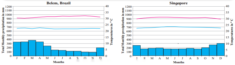
2. Read the graphs and answer the following questions. (Textbook Page No. 46)
Question 1
Maharashtra Board Solution
In which months there is no rainfall?
Solution & Step-by-Step Answer:
In both Belem and Singapore it rains throughout the year.
Question 2
Maharashtra Board Solution
In which month is the temperature highest?
Solution & Step-by-Step Answer:
The temperatures is highest in the month of October in Belem and in the month of May in Singapore.
Question 3
Maharashtra Board Solution
In which month is the temperature lowest?
Solution & Step-by-Step Answer:
The temperature is lowest in the months of January and February in Belem and in the month of December and January in Singapore.
Question 4
Maharashtra Board Solution
What could be the factors which influence the climate of these places?
Solution & Step-by-Step Answer:
Both Belem and Singapore lie in the equatorial region, i.e., at 1° 27′ S to 48° 30′ W and 1° 17′ N and 103° 51′ E respectively. Thus, in both Belem and Singapore, the climate is characterised by uniform temperature and pressure, high humidity and abundant rainfall as the sunrays are perpendicular on the equator throughout the year.
Question 5
Maharashtra Board Solution
Write a concluding statement about the climate of both the places based on the questions above.
Solution & Step-by-Step Answer:
Both cities experiences rainfall throughout the year. These is no dry season month. Average temperature varies little throughout. There is no distinct season, uniform temperature, high humidity and abundant rainfall. They have equatorial type of climate.
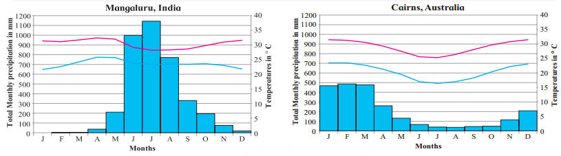
3. Read the graph and answer the following questions. (Textbook Page No. 47)
Question 1
Maharashtra Board Solution
Name the months of highest and lowest rainfall. What is the difference between the values of rainfall?
Solution & Step-by-Step Answer:
In Mangaluru highest rainfall month is July with around 1143 mm rainfall and lowest rainfall was found in the month of January which is the driest month. Thus, the difference between the values of rainfall is 1143 mm.
In Cairns highest rainfall is 486 mm in the month of February and least amount of rainfall occurs in August around 37 mm. Thus, the difference between the values of rainfall is 449 mm.
Question 2
Maharashtra Board Solution
Name the months of highest and lowest temperature.
Solution & Step-by-Step Answer:
Highest and Lowest temperature in Mangaluru is in April around 32.4°C and in January with 21.6°C respectively. Highest and lowest temperature in Cairns is in January at around 27.5° C and July being coldest month 16.4°C respectively.
Question 3
Maharashtra Board Solution
Are the months of rainfall same in both the places? If not, why?
Solution & Step-by-Step Answer:
No, the months of rainfall are not same in both the places. It rains in Mangaluru from May to November whereas, in Cairns rainfall is observed in the months from November to May.
Question 4
Maharashtra Board Solution
What could be the factors which influence the climate of these places?
Solution & Step-by-Step Answer:
The major factor which influences the climate of Mangaluru and Cairo is that Mangaluru lies in Northern hemispheres and Cairns in Southern hemispheres.
Question 5
Maharashtra Board Solution
What difference do you find in the graphs in fig and these?
Solution & Step-by-Step Answer:
There is variation in rainfall and temperature graphs of Mangaluru and Cairo as these lies in different hemispheres while the graphs of Fig. represent same temperature and rainfall throughout the year at Belem and Singapore. Both lie in the equatorial region, so not much variation is observed.
Question 6
Maharashtra Board Solution
Write a concluding statement about the climate of both the places.
Solution & Step-by-Step Answer:
The climate of Mangaluru and Cairo is tropical. There is significant rainfall in most of the months of the year with short dry season. In Mangaluru, January is the driest month with 00 mm. of precipitation. Most of the precipitation is in July. While, in Cairo, the least amount of rainfall occurs in August. In February, precipitation is the highest.
4. Read the graph and answer the following questions. (Textbook Page No. 48)
Question 1
Maharashtra Board Solution
In which months is there no rainfall?
Solution & Step-by-Step Answer:
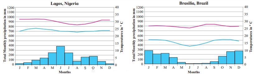
It rains throughout the year in both Lagos and Brasilia.
Question 2
Maharashtra Board Solution
In which month is the temperature highest?
Solution & Step-by-Step Answer:
Temperature is highest in the month of March in Lagos and in the month of September in Brasilia.
Question 3
Maharashtra Board Solution
In which month is the temperature lowest?
Solution & Step-by-Step Answer:
The temperature is lowest in Lagos in the month of August and that in the month of June in Brasilia.
Question 4
Maharashtra Board Solution
Are the months of rainfall same in both the places? If not, why?
Solution & Step-by-Step Answer:
It is wettest in June in Lagos and January is the wettest month in Brasilia, Lagos is situated near the equator. Thus, there is significant precipitation difference between the rainy season and summer season.
Brasilia is located at the top of Brazilian highlands. It has milder climate due to elevation and with two distinct seasons, the rainy season and dry season.
Question 5
Maharashtra Board Solution
What could be the factors influencing the climate of these places?
Solution & Step-by-Step Answer:
Lagos being near the equator and Brasilia located on the Brasilia highland, influences the climate of these places.
Question 6
Maharashtra Board Solution
What difference do you find in the previous and these graphs?
Solution & Step-by-Step Answer:
The total monthly precipitation is light in Mangaluru in the month of June, July, August and that of Cairns in the month of January, February, March whereas in equatorial region precipitation is experienced throughout the year. From this the graph of monsoon climate, we find that maximum precipitation is during the months of June to September.
Question 7
Maharashtra Board Solution
Write a concluding statement about the climate of both the places.
Solution & Step-by-Step Answer:
The rainfall is much more in summer than the winters in Lagos. The least amount of rainfall occurs in December while greater amount of precipitation occurs in June. The temperature is higher on an average in March, whereas lowest temperature occurs in August. With regards to Brasilia here too the rainfall is much more in summer than the winters. Precipitation is lowest in June and highest in January, September is the hottest month and lowest temperature is in June.
5. Read the graph and answer the following questions. (Textbook Page No. 48)
Question 1
Maharashtra Board Solution
Name the months of highest and lowest rainfall. What is the difference between the values of rainfall?
Solution & Step-by-Step Answer:
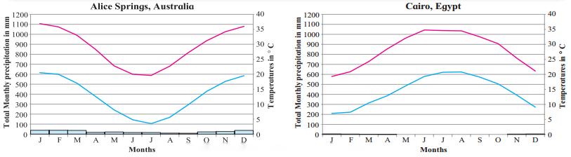
In Alice Springs, September is the driest month with around just 10 mm rainfall. Whereas the most precipitation falls in the month of January around 38 mm. The difference between the value is around 28 mm. Similarly, In Cairo, the driest month is May with no precipitation at all whereas it rains about 5 mm in the month of January. The difference between the values is just 5 mm.
Question 2
Maharashtra Board Solution
Name the months of highest and lowest temperature.
Solution & Step-by-Step Answer:
The warmest month in Alice Springs is January with an average temperature of 38.7°C while July experiences lowest temperature of about 11.5°C. In Cairo, July is the warmest month with 27.6°C and lowest temperatures is in January with around 13.1°C temperature.
Question 3
Maharashtra Board Solution
Are the months of rainfall same in both the place? If not, why?
Solution & Step-by-Step Answer:
No, the months of rainfall are not same in both the places because Alice Springs lies in the Southern Hemisphere while Cairo lies in the Northern Hemisphere.
Question 4
Maharashtra Board Solution
What could be the factors which influence the climate of these places?
Solution & Step-by-Step Answer:
Cairo in Egypt is located to the north of Tropic of Cancer, and Alice Springs is located just south of Tropic of Capricorn. Therefore, both the areas come under subtropical high-pressure belt. The air becomes dry here. The winds in this region blows out of the region, so there is very low rainfall. The region of Alice Springs is part of central Ranges scrub area of dry scrubby grasslands. Majority of the Egypt’s landscape is desert, hence extreme aridity is experienced.
Question 5
Maharashtra Board Solution
What difference do you find in the previous and these graphs?
Solution & Step-by-Step Answer:
In the previous graphs rainfall is depicted for almost all the months. But in the graphs representing climate of Alice Springs and Cairo, rainfall is very low or almost negligible. Temperature variation can also be depicted in the previous graphs and graphs of Alice Springs and Cairo.
Question 6
Maharashtra Board Solution
Write a concluding statement about the climate of both the places.
Solution & Step-by-Step Answer:
Rainfall is very less in Alice Springs whereas almost negligible in Cairo. This is due to the latitudinal extent of both the places and subtropical high-pressure belt. Cairo is in or near the subtropical desert biome whereas Alice Springs is in or near subtropical desert scrub biome. The average annual temperature is 35°C warmer. Average monthly temperature varies by 3.7°C in Cairo.
6. Read the graph and answer the following questions. (Textbook Page No. 50)
Question 1
Maharashtra Board Solution
Name the months of highest rainfall.
Solution & Step-by-Step Answer:
Perth experiences highest rainfall in the month of June whereas Rome experiences highest rainfall in November.
Question 2
Maharashtra Board Solution
Name the months of lowest temperatures.
Solution & Step-by-Step Answer:
The temperature in Perth is the lowest in July and the temperature in Rome is the lowest in January.
Question 3
Maharashtra Board Solution
Are the answers to 1 and 2 same?
Solution & Step-by-Step Answer:
No, the answers are not same.
Question 4
Maharashtra Board Solution
Are the months of rainfall same in both the places If not, why?
Solution & Step-by-Step Answer:
No, it does not rain in the same months in Perth and Rome. Perth lies on 31°57′ S to 115°51′ E longitude and Rome lies on 41°53′ N to 12°30′ E longitude. It means Perth is located in the Southern | Hemisphere, whereas Rome is in the Northern Hemisphere. Perth is near the Subtropical dry forest biome, whereas Rome is near the warm temperate moist forest biome.
Question 5
Maharashtra Board Solution
What could be the factors which influence the climate of a place?
Solution & Step-by-Step Answer:
The special feature of climate of this region is long dry summers and mild and wet winters. This because of subtropical high pressure in summer and westerly wind movement in winter.
Question 6
Maharashtra Board Solution
What difference do you find in the previous graphs and these graphs?
Solution & Step-by-Step Answer:
In Mediterranean regions, summers are long and warm and dry whereas winters are mild and wet. They are different from low-latitudinal climates where the temperature is high throughout the year. Rainfall in winter is the characteristic of this region but previous graph shows very meagre rainfall.
Question 7
Maharashtra Board Solution
Write a concluding statement about the climate of both the places.
Solution & Step-by-Step Answer:
Rainfall is highest in the month of June, around 175 mm in Perth, while its lowest in the month of January around just 7 mm. Whereas, November experiences highest rainfall of about 114 mm and lowest of about 17 mm in July in Rome. Temperature reaches its highest in February around 24.8°C and lowest in July around 13.6°C in Perth, while July experiences highest temperature of about 24.4° C and least about 7.7° in January in Rome.
7. Read the graph and answer the following questions. (Textbook Page No. 51)
Question 1
Maharashtra Board Solution
Name the months of highest and lowest rainfall.
Solution & Step-by-Step Answer:
In Brisbane, highest rainfall occurs in the months of February, while lowest rainfall is in the month of September. In Shanghai, June experiences highest rainfall, while precipitation is lowest in December.
Question 2
Maharashtra Board Solution
Name the months of highest and lowest temperatures. Relate them with rainfall months.
Solution & Step-by-Step Answer:
In Brisbane temperature is highest in January and lowest in July, while Shanghai experiences highest temperature in July and lowest in January. In Brisbane, temperature is highest in January whereas rainfall is highest in February and high in January, whereas in Perth, July records highest temperature and June records highest rainfall. Similarly, temperature is least in January and rainfall is least in December.
Question 3
Maharashtra Board Solution
Are the months of rainfall same in both the places? If not why?
Solution & Step-by-Step Answer:
No, both places have rainfall in different months. This is probably because Brisbane is located is Southern Hemisphere. Brisbane is in the south east corner of Queensland. The region is on the coastal plains, east of Great Dividing Range. Shanghai is located in the Northern Hemisphere, located on Yangtze River Delta on China’s east coast and has proximity to the Pacific Ocean via East China Sea.
Question 4
Maharashtra Board Solution
What could be the factors which influence the climate of these places?
Solution & Step-by-Step Answer:
Brisbane and Shanghai, both lie in the eastern parts of the southern and northern hemispheres respectively. Due to proximity to the coral sea of the Pacific Ocean and warm ocean current, Brisbane’s overall temperature variability is somewhat less.
Shanghai is located in the middle of China’s east coast near the mouth of river Yangtze to the North, the East china sea to the east, Hangzhou Bay to the south and Jiangsu and Zhejiang provinces to the west.
Question 5
Maharashtra Board Solution
What difference do you find in the previous and these graphs?
Solution & Step-by-Step Answer:
The major difference between Mediterranean and China type is that, the Mediterranean is found on the western margins of the continents while china type is found is the eastern parts almost in same latitudes. In Mediterranean type winter rainfall is the characteristics feature, while china type experiences rainfall throughout the year.
Question 6
Maharashtra Board Solution
Write a concluding statement about the climate of both the places.
Solution & Step-by-Step Answer:
Both the places receive rainfall from convectional showers. Precipitation is year-round. In Brisbane variation in the precipitation between driest and wettest months is 133 mm. During the year, average temperatures vary by 10.3°C.
8. Read the graph and answer the following questions. (Textbook Page No. 52)
Question 1
Maharashtra Board Solution
In which months do you find temperature the lowest?
Solution & Step-by-Step Answer:
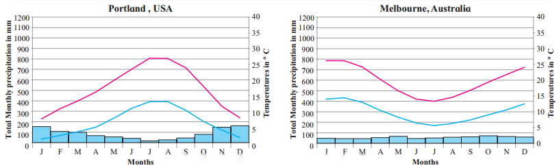
Temperature is the lowest in the month of January in Portland and in Melbourne it’s in the month of July.
Question 2
Maharashtra Board Solution
In which month is the precipitation lowest?
Solution & Step-by-Step Answer:
Precipitation is lowest in the month of July in Portland and lowest precipitation is found in the month of February in Melbourne.
Question 3
Maharashtra Board Solution
What are the highest values of precipitation?
Solution & Step-by-Step Answer:
In Portland highest precipitation is in the month of December with an average of 162 mm. While, highest value of precipitation in Melbourne is in October with an average of 71 mm.
Question 4
Maharashtra Board Solution
Name the months with no precipitation at all.
Solution & Step-by-Step Answer:
It rains throughout the year in both Portland and Melbourne.
Question 5
Maharashtra Board Solution
Write a concluding paragraph about this climatic region.
Solution & Step-by-Step Answer:
Marine west European type of climate is located between 40° and 65° latitudes in both the hemispheres along the western coasts of the continents. This climatic region is surrounded by Mediterranean climate in the south continental dry climate in the east and semi-arctic climate in the north. The temperatures are affected by marine influences, warm ocean currents and prevailing winds. This climate is characterised by cool summer and wild winters. Average temperature during summer season ranges between 15°C and 21°C. It rains throughout the year.
9. Read the graph and answer the following questions. (Textbook Page No. 53)
Question 1
Maharashtra Board Solution
Note the values of the axes, how different are these graphs from the earlies ones?
Solution & Step-by-Step Answer:
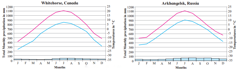
The values of Taiga or Sub-Arctic regions show the mean annual temperature below freezing point (0°C) that is from 0° to -35° C. These values are not observed in rest of the graphs.
Question 2
Maharashtra Board Solution
Note the highest and the lowest temperature and their months.
Solution & Step-by-Step Answer:
In Whitehorse, the highest temperature recorded is around 20.0°C in the month of July, whereas January is the coldest month with average temperature of -23°C. In Arkhangelsk, the highest temperature is in the month of July around 20°C and lowest in the month of January around -18°C.
Question 3
Maharashtra Board Solution
Note the highest and lowest rainfall and their months.
Solution & Step-by-Step Answer:
Highest rainfall recorded is about 35 to 37 mm in the months of July, August in Whitehorse and lowest is in the month of April with just 9 mm. In Arkhangelsk, the greatest amount of precipitation occurs in August with an average of 66 mm. The lowest amount of rainfall occurs in February. The average is this month in 27 mm.
Question 4
Maharashtra Board Solution
Why does not a place from Southern Hemisphere appear here?
Solution & Step-by-Step Answer:
There isn’t much land at higher latitudes in hemisphere (until inside the Antarctic circle where it is permanently ice covered) and most of that land is fairly close to oceans and it has effect of marine warming.
Question 5
Maharashtra Board Solution
What factors are responsible for this climate?
Solution & Step-by-Step Answer:
Located in large Continental landmass between 55° to 65° latitude, the Sub-Arctic climate is removed from any moderating influence of an ocean. It therefore, experiences a very large range in annual temperature. During the summer it is dominated by the westerlies and cyclonic activity the winter it is the polar hight and Easterlies. The Sub-Arctic climate has continental polar air masses.
10. Read the graph and answer the following questions. (Textbook Page No. 54)
Question 1
Maharashtra Board Solution
Why is it that both the graphs are from the northern Hemisphere?
Solution & Step-by-Step Answer:
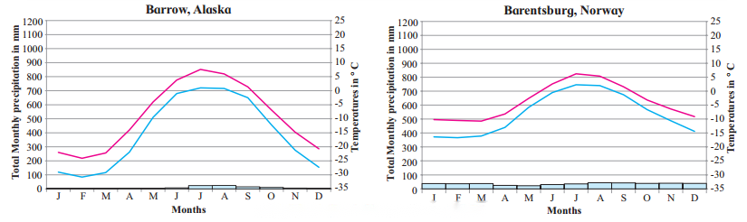
Tundra is located at the top of the world, near the north pole. Tundra is a Finnish word which means barren land. Thus, Tundra region having least vegetation and polar or arctic climate is found in North America and Eurasia between the southern limit of the permanent ice caps in the north and the northern limit of temperate coniferous forest of taiga climate in the south.
Question 2
Maharashtra Board Solution
Which are the warmest and the coolest months?
Solution & Step-by-Step Answer:
In Barrow, the warmest month is July while lowest temperature is in the month of February. Same temperature conditions are observed in Barentsburg.
Question 3
Maharashtra Board Solution
What is the annual range of temperature?
Solution & Step-by-Step Answer:
The average annual range of temperature in Barrow is -12.2°C while in Barentsburg it is -5.9° C.
Question 4
Maharashtra Board Solution
Why does not the duration of day (sometimes more than 24 hours) influence its temperatures or precipitation?
Solution & Step-by-Step Answer:
This is because the sun’s rays are oblique and little insolation is received being at higher latitude -65° to 90° North.
11. Read the graph and answer the following questions. (Textbook Page No. 55)
Question 1
Maharashtra Board Solution
Which are the warmest and the coolest months?
Solution & Step-by-Step Answer:
The warmest month is July and the coolest month is February in Eismitte. While in Scott South Station warmest months are December and January and coolest month is August.
Question 2
Maharashtra Board Solution
Name the months of highest and lowest rainfall.
Solution & Step-by-Step Answer:
The month with highest rainfall in Eismitte is December and lowest rainfall is in May. While in Scott South Station highest rainfall is in the month of February, while lowest rainfall is observed in July and August.
Question 3
Maharashtra Board Solution
In what way do you find similarities of this climate with other climate types of high latitudes?
Solution & Step-by-Step Answer:
Precipitation is very low in high latitude regions and mostly it is in the form of snowfall. Temperature is below freezing point (CPC) in all the high latitude regions. This is because the sun’s rays are oblique and hence temperature is low. These regions are mostly under permanent snow cover.
Question 4
Maharashtra Board Solution
What factors influence this type of climate?
Solution & Step-by-Step Answer:
Little or no insolation during most of the months in a year, oblique sunrays are the factors responsible for this type of climate.
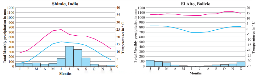
12. Read the graph and answer the following questions. (Textbook Page No. 56)
Question 1
Maharashtra Board Solution
Which are the warmest and the coolest months?
Solution & Step-by-Step Answer:
The warmest month is June while coolest month is January in Shimla. November is the hottest month and July is the coolest month in El Alto.
Question 2
Maharashtra Board Solution
Name the months of highest and lowest precipitation.
Solution & Step-by-Step Answer:
Most of the precipitation is in the months of July, whereas driest month is November is in Shimla. Precipitation is highest in January and lowest in June in El Alto.
Question 3
Maharashtra Board Solution
In what ways do you find similarities of this climate with other types of high latitudes?
Solution & Step-by-Step Answer:
In these regions, precipitation is in the form of snowfall. The regions are covered by snow. Temperature is very low, as the sunrays are oblique and little insolation is received. Temperature decreases with increasing altitude.
Question 4
Maharashtra Board Solution
Why are the axis showing temperature different in both the graphs?
Solution & Step-by-Step Answer:
Shimla is located at 31°6 N to 77°10 and its elevation is 2.276 m whereas El Alto is located on 16°31 S to 68°10 W with an elevation of 4.150 mts. Temperature decreases with increasing altitude. Thus, the axis is different temperature in both the graphs.
Question 5
Maharashtra Board Solution
What factors influence this type of climate?
Solution & Step-by-Step Answer:
The higher reaches of mountain, altitude, location of leeward or windward side, precipitation are the factors affecting climates of mountain type of climate.
Find out! (Textbook Page No. 44) Use internet or reference books to find out about the attempts at classification of climates. |