Latest Maharashtra State Board (SSC & HSC) 2026-27 Syllabus Digest & Solutions Updated!
Class 6Geography2026-27 Syllabus

Chapter 1 The Earth and the Graticule Solutions

Complete Maharashtra State Board Balbharati & Yuvakbharati textbook solutions for Chapter 1 The Earth and the Graticule. Step-by-step solved exercises, numerical problems, and digest answers.

56 Solved Questions5 Diagrams2246 words

Maharashtra Board Class 6 Geography Solutions Chapter 1 The Earth and the Graticule

Class 6 Geography Chapter 1 The Earth and the Graticule Textbook Questions and Answers

A. Place a tick mark (✓) against the correct option:

Question 1 Maharashtra Board Solution
What term is used for the imaginary east-west horizontal lines on the earth? (i) Meridians (ii) International Date Line (iii) Parallels
Solution & Step-by-Step Answer:
Parallels
Question 2 Maharashtra Board Solution
What is the shape of the meridians? (i) Circular (ii) Semicircular (iii) Points
Solution & Step-by-Step Answer:
Semicircular
Question 3 Maharashtra Board Solution
What do the parallels of latitude and meridians of longitude together form on the globe? (i) Angular distance (ii) Hemisphere (iii) Graticule
Solution & Step-by-Step Answer:
Graticule
Question 4 Maharashtra Board Solution
How many parallels are there in the northern hemisphere? (i) 90 (ii) 89 (iii) 91
Solution & Step-by-Step Answer:
90
Question 5 Maharashtra Board Solution
Which circles form the eastern and western hemispheres? (i) 0° parallel and 180° meridian (ii) 0° Prime Meridian and 180° meridian (iii) North and South Polar circles
Solution & Step-by-Step Answer:
0° Prime Meridian and 180° meridian
Question 6 Maharashtra Board Solution
Which circle appears as a point on the globe? (i) Equator (ii) North/South Pole (iii) Prime Meridian
Solution & Step-by-Step Answer:
North/South Pole
Question 7 Maharashtra Board Solution
How many places on the earth may be located on 45° N parallel? (i) One (ii) Many (iii) Two
Solution & Step-by-Step Answer:
Many

B. Observe a globe and examine the following statements. Correct the wrong ones:

Question 1 Maharashtra Board Solution
Parallels of latitude lie parallel to the Prime Meridian,
Solution & Step-by-Step Answer:
Wrong: Parallels of latitude lie parallel to the equator.
Question 2 Maharashtra Board Solution
All parallels of latitude converge at the equator.
Solution & Step-by-Step Answer:
Wrong: All meridians of longitude converge at the poles.
Question 3 Maharashtra Board Solution
Parallels and meridians are imaginary lines.
Solution & Step-by-Step Answer:
Right.
Question 4 Maharashtra Board Solution
8° 4′ 65″ N is a north meridian.
Solution & Step-by-Step Answer:
Wrong: 8° 4′ 65″ N is a north parallel.
Question 5 Maharashtra Board Solution
Meridians are parallel to each other.
Solution & Step-by-Step Answer:
Wrong: Latitudes are parallel to each other.

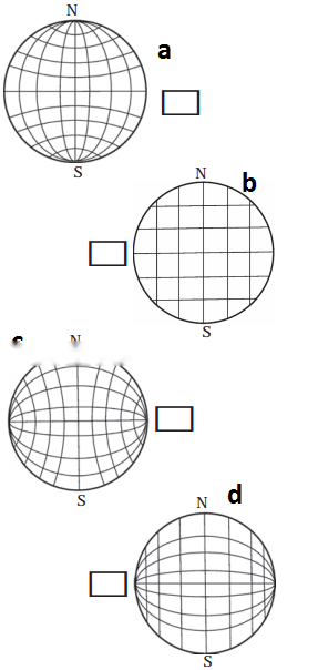
C. Find the correct graticule out of the following and put a tick mark against it.

Answer:
Figure (a) is correct.
D. Answer the following:

Question 1 Maharashtra Board Solution
How will you express the latitude and longitude of the North Pole?
Solution & Step-by-Step Answer:
The latitude of the North Pole would be 90°N. All the meridians of longitudes pass through the North Pole. So the North pole would be 0° longitude.
Question 2 Maharashtra Board Solution
How much is the angular distance between the Tropic of Cancer and Tropic of Capricorn?
Solution & Step-by-Step Answer:
The angular distance between the tropic of Cancer and tropic of Capricorn is 23°30′ + 23°30′ = 47°
Question 3 Maharashtra Board Solution
Using a globe, write down the names of the countries through which the equator passes.
Solution & Step-by-Step Answer:
The countries through which the equator passes are Ecuador, Colombia, Brazil, Sao tome and Principe, Gabon, Republic of the Congo, Democratic Republic of the Congo, Uganda, Kenya, Somalia, Maldives, Indonesia and Kiribati.
Question 4 Maharashtra Board Solution
Write down the main uses of the graticule.
Solution & Step-by-Step Answer:
Graticules help us to determine the locations on the earth. In the modern age, Geographical Information Systems, Global Positioning System, Google Maps, Wikimapia, Bhuvan of ISRO also make use of graticules.

E. Complete the following table:

Characteristics

Parallels of latitude

Meridians of longitude

Shape

Size of each parallel is different

Distance

Distance between two meridians is larger on the equator and the same decreases towards the Poles.

Answer:

Characteristics

Parallels of latitude

Meridians of longitude

Shape

Circular

Semicircular

Size

Size of each parallel is different

Size of each meridian is same

Distance

Distance between two parallels is the same everywhere

Distance between two meridians is larger on the equator and the same decreases towards the Poles.

Class 6 Geography Chapter 1 The Earth and the Graticule Textbook Questions and Answers

Think a little!

Question 1 Maharashtra Board Solution
A game of reading the meridians on the world map is going on. Shaheen and Sanket are asking each other to locate places on specific meridians and are making notes of the same. Shaheen asks Sanket to locate Wrangel Island on 180° meridians. Sanket could locate the island in the map but both are confused while making a note of it. They are puzzled whether to write 180° E or 180° W? What would be the precise answer? Please help them. Can we use a similar logic with reference to 0° meridian as well?
Solution & Step-by-Step Answer:
The 0° and the 180° meridians lie opposite to each other and form a circle around the earth. This circle divides the earth in the eastern and western hemisphere. Shaheen and Sanket can write the Wrangled island to be loacted on 180° meridian.

Do it yourself!

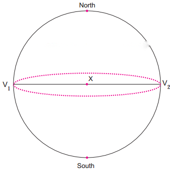
Use figure 1.4 of the geography textbook:

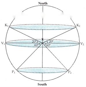
In the upper portion of the circle, at the centre X, draw angles of 30°, V1X K1and V2X K2; K1and K2being the points on the circle. Draw an ellipse joining K1and K2.
In the lower half of the circle, mark angles of 60° and name the points on the circle as P1and P2.
Question 1 Maharashtra Board Solution
Draw an ellipse joining P1 and P2.
Solution & Step-by-Step Answer:

Can you tell?

Question 1 Maharashtra Board Solution
Is the distance between K1 K2 and P1 P2 the same?
Solution & Step-by-Step Answer:
No, the distance between K1 K2 and P1 P2 are not the same.
Question 2 Maharashtra Board Solution
Compare the distances XK1 and XP2. Are these distances the same or are they different?
Solution & Step-by-Step Answer:
Yes, the distances are the same.
Question 3 Maharashtra Board Solution
Now compare the ellipses you have drawn. Which is the larger ellipse? Why?
Solution & Step-by-Step Answer:
The ellipse through K1 and K2 is larger than the ellipse through P1 and P2. This is because the distance between K1 K2 is greater than the distance between P1 P2.

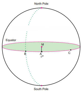
Observe the picture (fig) on page 5 of the textbook and answer the following questions:


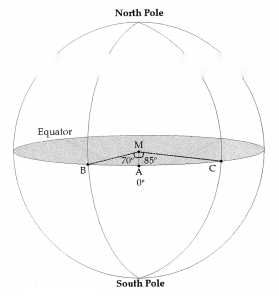
Let the line AM be 0°.
Draw the line MB. Measure the angle it makes with the line AM and write it near B. Note the semicircle that passes through B and joins the North and South Poles. Trace it.
Now join MC. Measure ∠AMC and write it next to C. Draw a semicircle that passes through ‘C’ and joins the North and South Poles.
Draw a line that passes through point A at 0°, and joins the North and South Poles.

Answer:
∠AMB = 70°
∠AMC = 85°
Use your brain power!

Question 1 Maharashtra Board Solution
How many parallels and meridians can be drawn on a globe at an interval of 10°?
Solution & Step-by-Step Answer:
19 parallels and 36 meridians can be drawn on a globe at an interval of 10°.

Class 6 Geography Chapter 1 The Earth and the Graticule Textbook Questions and Answers

Fill in the blanks choosing the correct options from the brackets:

Question 1 Maharashtra Board Solution
A miniature model of the earth is called a _____.(ball, globe, sphere)
Solution & Step-by-Step Answer:
globe
Question 2 Maharashtra Board Solution
The location of any place on the earth is determined with reference to the ______ of the earth. (poles, circle, centre)
Solution & Step-by-Step Answer:
centre
Question 3 Maharashtra Board Solution
The _______ is considered as 0° parallel.(equator, poles, circles)
Solution & Step-by-Step Answer:
equator
Question 4 Maharashtra Board Solution
The ______ bisects the earth into north and south parts. (poles, equator, circles)
Solution & Step-by-Step Answer:
equator
Question 5 Maharashtra Board Solution
One can draw _____ parallels on the earth at the interval of 1°. (90,181,360)
Solution & Step-by-Step Answer:
Question 6 Maharashtra Board Solution
The 0° meridian is known as the _____. (Central meridian, Equator, Prime Meridian)
Solution & Step-by-Step Answer:
Prime Meridian
Question 7 Maharashtra Board Solution
Each degree is divided into 60 ______.(minutes, hours, seconds)
Solution & Step-by-Step Answer:
minutes
Question 8 Maharashtra Board Solution
One can draw _____ meridians each at a distance of 1°. (90,181, 360)
Solution & Step-by-Step Answer:
360
Question 9 Maharashtra Board Solution
All meridians are _______ in size.(unequal, equal, uneven)
Solution & Step-by-Step Answer:
equal
Question 10 Maharashtra Board Solution
Exact location of a place on the earth can be located using ______.(equator, latitude and longitude, Prime Meridian)
Solution & Step-by-Step Answer:
latitude and longitude
Question 11 Maharashtra Board Solution
The distance between any two adjacent parallels is _______ on the surface of the earth. (111 km, 102 km, 44 km)
Solution & Step-by-Step Answer:
111 km
Question 12 Maharashtra Board Solution
The parallels and meridians on the globe form a net that is called a ______.(latitude,graticule, longitude)
Solution & Step-by-Step Answer:
graticule

Match the pairs correctly:

Question 1 Maharashtra Board Solution

Different parallels

Distance between meridians

(1) Poles

(a) 111 km

(2) Tropic of Cancer

(b) 102 km

(3) Polar Circles

(c) 0 km

(4) Equator

(d) 44 km

(5) Meridians

(e) 360

(f) 1°

Solution & Step-by-Step Answer:

1 – c
2 – b
3 – d
4 – a
5 – e

Place a tick mark (✓) against the correct option:

Question 1 Maharashtra Board Solution
Which meridian is considered as the Prime Meridian? (i) 0° (ii) 80° (iii) 90°
Solution & Step-by-Step Answer:

Answer the following questions in one sentence:

Question 1 Maharashtra Board Solution
What are parallels of latitudes?
Solution & Step-by-Step Answer:
Ellipses that are created at some angular distance from the centre of the earth and are parallel to one another are called parallels of latitudes.
Question 2 Maharashtra Board Solution
How many parallels are there in the northern hemisphere?
Solution & Step-by-Step Answer:
There are 90 parallels in the northern hemisphere.
Question 3 Maharashtra Board Solution
Which circle divides the earth in the eastern and western hemisphere?
Solution & Step-by-Step Answer:
The Prime Meridian divides the earth in the eastern and western hemisphere.
Question 4 Maharashtra Board Solution
What is the distance between any two adjacent parallels on the surface of the earth?
Solution & Step-by-Step Answer:
The distance between any two adjacent parallels on the surface of the earth is 111 km.
Question 5 Maharashtra Board Solution
What is a graticule?
Solution & Step-by-Step Answer:
The parallels and meridians on the globe form a net that is called a graticule.
Question 6 Maharashtra Board Solution
What is used to determine the location on the earth?
Solution & Step-by-Step Answer:
Latitude and longitude is used to determine the location on the earth.

Write the full forms of:

Question 1 Maharashtra Board Solution
GIS
Solution & Step-by-Step Answer:
Geographical Information System
Question 2 Maharashtra Board Solution
GPS
Solution & Step-by-Step Answer:
Global Positioning System
Question 3 Maharashtra Board Solution
IRNSS
Solution & Step-by-Step Answer:
Indian Regional Navigation Satellite System
Question 4 Maharashtra Board Solution
ISRO
Solution & Step-by-Step Answer:
Indian Space Research Organisation

Give geographical reasons for the following statements:

Question 1 Maharashtra Board Solution
Parallels and meridians are imaginary lines on the earth.
Solution & Step-by-Step Answer:
Parallels and meridians can be drawn on a globe though not on the earth. That is why parallels and meridians are imaginary lines on the earth.
Question 2 Maharashtra Board Solution
Geographers developed a miniature model of the earth in the form of a globe.
Solution & Step-by-Step Answer:
Oceanic waters, uneven nature of the land, forest, innumerable islands of different sizes and buildings make it impossible to draw lines on the earth. In order to overcome this difficulty, geographers developed a miniature model of the earth in the form of a globe.
Question 3 Maharashtra Board Solution
Latitude and longitudes are expressed into degree, minutes and seconds.
Solution & Step-by-Step Answer:
To locate the places within the distance of 111 km exactly, the unit degree is divided into smaller units. Degrees are divided into minutes and seconds.

Answer the following questions in short:

Question 1 Maharashtra Board Solution
Explain the meaning of the term ‘equator’.
Solution & Step-by-Step Answer:
Question 2 Maharashtra Board Solution
What are Poles of the earth?
Solution & Step-by-Step Answer:
On the globe and also on the earth, at the north and south ends of the earth’s axis, Poles appear as points. These are called the North Pole and the South Pole respectively.

Observe a globe and examine the following statements. Correct the wrong ones:

Question 1 Maharashtra Board Solution
Parallels of latitude lie parallel to the Prime Meridian,
Solution & Step-by-Step Answer:
Wrong: Parallels of latitude lie parallel to the equator.
Question 2 Maharashtra Board Solution
All parallels of latitude converge at the equator.
Solution & Step-by-Step Answer:
Wrong: All meridians of longitude converge at the poles.
Question 3 Maharashtra Board Solution
Parallels and meridians are imaginary lines.
Solution & Step-by-Step Answer:
Right.
Question 4 Maharashtra Board Solution
80° 4′ 65″ N is a north meridian.
Solution & Step-by-Step Answer:
Wrong: 80° 4′ 65″ N is a north parallel.
Question 5 Maharashtra Board Solution
Meridians are parallel to each other.
Solution & Step-by-Step Answer:
Wrong: Latitudes are parallel to each other.