Latest Maharashtra State Board (SSC & HSC) 2026-27 Syllabus Digest & Solutions Updated!
Class 6Geography2026-27 Syllabus

Chapter 2 Let us Use the Graticule Solutions

Complete Maharashtra State Board Balbharati & Yuvakbharati textbook solutions for Chapter 2 Let us Use the Graticule. Step-by-step solved exercises, numerical problems, and digest answers.

55 Solved Questions6 Diagrams1995 words

Maharashtra Board Class 6 Geography Solutions Chapter 2 Let us Use the Graticule

Class 6 Geography Chapter 2 Let us Use the Graticule Textbook Questions and Answers

A. Put a tick mark against the correct option in the space given:

Question 1 Maharashtra Board Solution
66° 30′ North parallel means: (i) Arctic Circle (ii) Equator (iii) Antarctic Circle
Solution & Step-by-Step Answer:
Arctic Circle
Question 2 Maharashtra Board Solution
Which parallel bisects the earth? (i) Tropic of Cancer (ii) Tropic of Capricorn (iii) Equator
Solution & Step-by-Step Answer:
Equator
Question 3 Maharashtra Board Solution
What is the angular distance of the Arctic Circle from North Pole? (i) 66° 30′ (ii) 90° (iii) 23° 30
Solution & Step-by-Step Answer:
23° 30′
Question 4 Maharashtra Board Solution
Where do the Prime Meridian and the equator • intersect each other? (i) Southern Ocean (ii) Atlantic Ocean (iii) African Continent
Solution & Step-by-Step Answer:
African Continent
Question 5 Maharashtra Board Solution
Up to which parallels from the equator can the j sun’s rays be perpendicular? (i) Tropic of Cancer and Tropic of Capricorn (ii) Arctic and Antarctic Circles (iii) North and South Poles
Solution & Step-by-Step Answer:
Tropic of Cancer and Tropic of Capricorn
Question 6 Maharashtra Board Solution
What would be the latitude of a place on the South pole? (i) 9o°S (ii) 90°N (iii) 0°D
Solution & Step-by-Step Answer:
90° S

B. Read the following statements and correct the wrong ones:

Question 1 Maharashtra Board Solution
While describing the location of a place mentioning the meridian is sufficient.
Solution & Step-by-Step Answer:
While describing the location of a place, we need to consider one parallel and one meridian.
Question 2 Maharashtra Board Solution
For describing the extent of a region, it is necessary to assume the latitude and longitude of the centre of the adjoining region.
Solution & Step-by-Step Answer:
For describing the extent of a region, we need to consider two parallels and two meridians at the extreme ends of the same regions.
Question 3 Maharashtra Board Solution
Location of a road can be described only with a map.
Solution & Step-by-Step Answer:
Location of a road can be described with latitude and longitude of a point.
Question 4 Maharashtra Board Solution
0° East meridian and 180° East meridian.
Solution & Step-by-Step Answer:
0° meridian and 180° meridian.
Question 5 Maharashtra Board Solution
The extent of a road or a river course is described with the help of the latitude of a point in the source and the longitude of a point at the end.
Solution & Step-by-Step Answer:
The extent of a road or a river course is described with the help of the latitude and the longitude of a point in the source and also at the end.
Question 6 Maharashtra Board Solution
8° 4′ N parallel to 37° 66° N parallel is the correct description of a location
Solution & Step-by-Step Answer:
8° 4’ N parallel to 37° 66’ N parallel is the correct description of a location.

C. Find the locations of following cities from a world map, a map of India or a Globe and write down the latitude and longitude of each of them:

Answer:

Place

Latitude

Longitude

Mumbai

19° 00′ N

72 48’ E

Guwahati

26° 12′ N

91 48’ E

Srinagar

34° 05′ N

74 50’ E

Bhopal

23° 18′ N

77 24’ E

Chennai

13° 06′ N

80 18’ E

ottawa

45° 27′ N

75 42’ W

Tokyo

35° 45′ N

139 45’ E

Johannesburg

26° 10′ S

28 03’ E

New York

43° 00′ N

75 00’ W

London

51° 31′ N

0 7’ W

D. Find and write down the extent of the following. (Check them on the internet/ mobile):

Question 1 Maharashtra Board Solution
Maharashtra (State)
Solution & Step-by-Step Answer:
Question 1. 20° 00′ N / 76° 00’E
Question 2 Maharashtra Board Solution
Chile (A country)
Solution & Step-by-Step Answer:
35° 00′ S / 72° 00’W
Question 3 Maharashtra Board Solution
Australia (A continent)
Solution & Step-by-Step Answer:
10° 30′ S to 43° 39′ S – 113° E to 153° E
Question 4 Maharashtra Board Solution
Sri Lanka (An island)
Solution & Step-by-Step Answer:
7° 30′ N / 80° 50′ E
Question 5 Maharashtra Board Solution
Trans Siberian Railway of Russia (Starting point – St. Petersburg, Terminal Point-Vladivostok)
Solution & Step-by-Step Answer:
59° 55′ N / 30° 20′ E – 43° 10′ N / 131° 53’ E

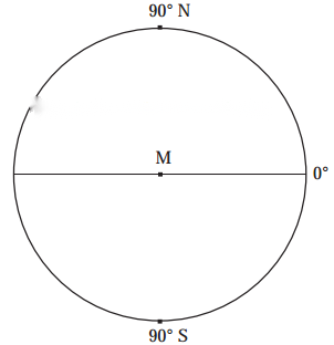
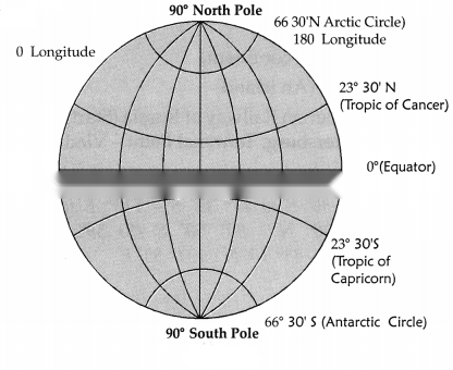
E. Draw important parallels and meridians in the figure given below and label them with appropriate angular measures. (Use the protractor.)

Answer:
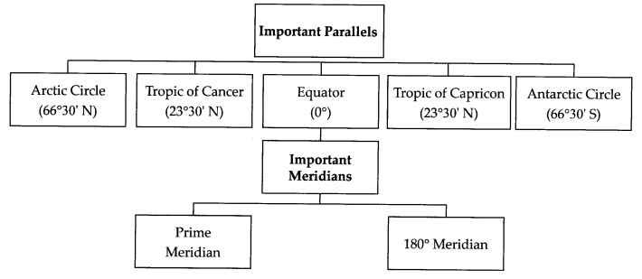
F. Write the important parallels and meridians in the following table:
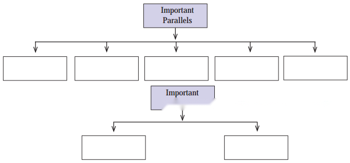
Answer:
Class 6 Geography Chapter 2 Let us Use the Graticule InText Questions and Answers

Make friends with the globe!

Observe the globe and answer the following questions.

Question 1.
What are the horizontal lines on the globe called?
Answer:
The horizontal lines on the globe are called latitudes.
Question 2 Maharashtra Board Solution
List the continents and oceans through which the equator passes.
Solution & Step-by-Step Answer:
Continents – Africa, South America, Asia Oceans – Pacific, Atlantic and Indian
Question 3 Maharashtra Board Solution
Encircle the intersection of 0° meridian and 0° parallel on the globe.
Solution & Step-by-Step Answer:
Students may attempt this question of their own.
Question 4 Maharashtra Board Solution
Which ocean is spread in all the four hemispheres?
Solution & Step-by-Step Answer:
Pacific Ocean
Question 5 Maharashtra Board Solution
Which continent is spread in all the four hemispheres?
Solution & Step-by-Step Answer:
The continent of Africa
Question 6 Maharashtra Board Solution
At which two parallels do all the meridians converge?
Solution & Step-by-Step Answer:
90°N and 90°S parallels.

State the Importance of the following:

Question 1 Maharashtra Board Solution
Prime Meridian
Solution & Step-by-Step Answer:
The main purpose is to fix the global standard time and co-ordinate the standard times of different countries.
Question 2 Maharashtra Board Solution
180° Meridian
Solution & Step-by-Step Answer:
The International Date Line is marked with reference to this meridian.
Question 3 Maharashtra Board Solution
Great Circles
Solution & Step-by-Step Answer:
Great Circles are used for finding the minimum distance between any two places on the surface of the earth.

Let us use the graticule:

Answer the following questions about the location and extent with the help of figure page 11 of your textbook.
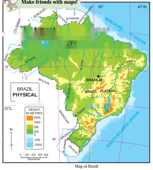
Question 1 Maharashtra Board Solution
Which latitude and longitude define the location of the capital of Brazil- Brasilia?
Solution & Step-by-Step Answer:
13°S latitude and 48°W longitude.
Question 2 Maharashtra Board Solution
What would be the longitudinal extent of Brazil that spreads from 5° 15′ N to 33° 45′ S latitude?
Solution & Step-by-Step Answer:
Longitudinal extent would be 34° 47’W to 73° 59’W.
Question 3 Maharashtra Board Solution
In which hemispheres does Brazil extend in the north-south direction?
Solution & Step-by-Step Answer:
Brazil extends in the both northern and southern hemispheres.
Question 4 Maharashtra Board Solution
In which hemisphere does Brazil extend in the east-west direction?
Solution & Step-by-Step Answer:
Brazil extends in the Western Hemisphere.
Question 5 Maharashtra Board Solution
Which parallels and meridians should be used to describe the extend of River Sao Francisco?
Solution & Step-by-Step Answer:
River Sao Francisco has its source at 40° 04′ W/ 20° 02’S and terminal point at 37°W/10°S.
Question 6 Maharashtra Board Solution
Describe the location of Marajo Island using the graticule.
Solution & Step-by-Step Answer:
Using the Graticules, the location of Marajo island is 0.4°N and 51°W.

Think a little!
Question 1.
Find on the globe, the meridians opposite to the ones mentioned below:
90°E, 170°W, 30°E, 20°W
Answer:

Think a little!

Question 1 Maharashtra Board Solution
Which important parallel passes through India?
Solution & Step-by-Step Answer:
Tropic of Cancer (23° 30′ N)
Question 2 Maharashtra Board Solution
Which areas do not get perpendicular rays?
Solution & Step-by-Step Answer:
Areas to the North of Tropic of Cancer (till Jammu and Kashmir).
Question 3 Maharashtra Board Solution
Which region receives perpendicular ray on two days in a year?
Solution & Step-by-Step Answer:
The region to the south of Tropic of Cancer (till Kaniyakumari).

Use your brain power!

Question 1 Maharashtra Board Solution
In what direction should an aeroplane fly in order to cover the shortest distance between Kolkata and Chicago?
Solution & Step-by-Step Answer:
To cover the shortest distance between Kolkata and Chicago, the aeroplane should move north west via Delhi.

Class 6 Geography Chapter 2 Let us Use the Graticule Additional Important Questions and Answers

Fill in the blanks:

Question 1 Maharashtra Board Solution
______ is known as the smallest country in the world.
Solution & Step-by-Step Answer:
Vatican City
Question 2 Maharashtra Board Solution
The International Date line is marked with reference to _____ meridian.
Solution & Step-by-Step Answer:
180°
Question 3 Maharashtra Board Solution
The Prime Meridian is known as ________.
Solution & Step-by-Step Answer:
Greenwich Meridian
Question 4 Maharashtra Board Solution
Global Standard Time is known as ______.
Solution & Step-by-Step Answer:
Greenwich Mean Time
Question 5 Maharashtra Board Solution
Variation in the intensity of sunlight leads to regional diversity in ____ and ______.
Solution & Step-by-Step Answer:
plant, animal life
Question 6 Maharashtra Board Solution
Different temperature zones give rise to ______ belts.
Solution & Step-by-Step Answer:
pressure
Question 7 Maharashtra Board Solution
The 180° meridian lies opposite to the _______.
Solution & Step-by-Step Answer:
Prime Meridian
Question 8 Maharashtra Board Solution
The equator as well as all pairs of opposite meridians form ______.
Solution & Step-by-Step Answer:
Great Circles
Question 9 Maharashtra Board Solution
Due to the ______ and _______ of sunlight, different temperature zones are formed on the earth.
Solution & Step-by-Step Answer:
duration, intensity
Question 10 Maharashtra Board Solution
All places between 23° 30′ north and south of equator receives _______ rays on two days in a year.
Solution & Step-by-Step Answer:
perpendicular

Match the pairs correctly:

Question 1 Maharashtra Board Solution

A (Latitudes)

B (Names)

(1)23°30’N

(a) Antarctic Circle

(2) 23°30′ S

(b) Tropic of Capricorn

(3)66°30’N

(c) Tropic of Cancer

(4) 66°30′ S

(d) Arctic Circle

(e) Great Circle

(f) Prime Meridian

Solution & Step-by-Step Answer:

1 – c
2 – b
3 – d
4 – a

Complete the following sentence:

Question 1 Maharashtra Board Solution
While describing the location of a place, we need to consider _______.
Solution & Step-by-Step Answer:
only one parallel and one meridian
Question 2 Maharashtra Board Solution
For describing the extent of a region, we need to consider _________.
Solution & Step-by-Step Answer:
two parallels and two meridians at the extreme ends of the region
Question 3 Maharashtra Board Solution
For describing the extent of linear features like a river or road we need to consider ______.
Solution & Step-by-Step Answer:
the latitudes and longitude of their terminal points
Question 4 Maharashtra Board Solution
All places between 23°30′ N and S of the ! equator receive perpendicular rays _____.
Solution & Step-by-Step Answer:
on two days in a year
Question 5 Maharashtra Board Solution
Depending on the seasons, daytime can be greater than 24 hours in areas between ________.
Solution & Step-by-Step Answer:
the polar circles and the poles
Question 6 Maharashtra Board Solution
All places between 23° 30′ N and South of equator ______ rays on two days in a year.
Solution & Step-by-Step Answer:
receive perpendicular

Answer the following questions in one sentence:

Question 1 Maharashtra Board Solution
What are Great Circles used for?
Solution & Step-by-Step Answer:
Great Circles are used for finding the minimum distance between any two places on the surface of the earth.
Question 2 Maharashtra Board Solution
Where is Vatican City located?
Solution & Step-by-Step Answer:
Vatican City is the smallest country in the world located within Italy on the Italian peninsula.
Question 3 Maharashtra Board Solution
Why is the Prime Meridian considered an important meridian?
Solution & Step-by-Step Answer:
The prime meridian is an important meridian because its main purpose is to fix the global standard time and co-ordinate the standard times of different countries.