Chapter 4 Climate
Textbook Questions and Answers
Question 1.
Write names of the States/Regions in appropriate columns.
Bihar, Tocantins, Pernambuco, Alagoas, Eastern Maharashtra, Western part of Rajasthan, Gujarat, Rio Grande Do Norte, Paraiba, Western Ghats, Eastern Himalayas, Western Andhra Pradesh, Roroima, Amazonas, West Bengal, Rio Grande Do Sul, Santa Catarina, Goa
Answer:
States/Regions | India | Brazil |
High rainfall | Western Ghats, Eastern Himalayas, Goa | Tocantins, Rio Grande Do Sul, Roraima |
Moderate rainfall | Bihar, Eastern Maharashtra West Bengal | Santa Catarina, Amazonas, Alagoas |
Low rainfall | Western part of Rajasthan, Gujarat, Western Andhra Pradesh | Pernambuco, Paraiba, Rio Grande Do Norte, Alagoas |
2. State whether right or wrong. Rewrite the wrong sentences
Question a.
The fact that Brazil lies on the equator affects its climate in a big way.
Answer:
Right.
Question b.
India and Brazil have the same seasons at the same time.
Answer:
Wrong – India and Brazil have different seasons at the same time.
Question c.
India faces tropical cyclones frequently.
Answer:
Right.
Question d.
Brazil gets a lot of rainfall because of the southwest monsoon winds.
Answer:
Wrong – Brazil gets rainfall from South-East Trade Winds and North-East Trade Winds.
3. Give geographical reasons:
Question a.
The north-eastern part of Brazilian Highlands receives very less rainfall.
Answer:
(i) Brazil gets rainfall from the South-East Trade Winds and the North-East Trade Winds.
(ii) Parts of the Brazilian Highlands extend upto the northern coast.
(iii) The Escarpments act as an obstruction to the winds blowing from the sea and cause orographic type of rainfall in the coastal region.
(iv) Beyond the Highlands, the effect of these winds gets reduced. As a result, the rainfall is minimal.
(v) Thus the North Eastern part of Brazilian highlands receives less rainfall. This rain shadow region is also called the ‘Drought Quadrilateral’.
Question b.
Snowfall doesn’t always occur in Brazil.
Answer:
(i) Because of the vast latitudinal extent of Brazil, it experiences a wide range of climatic variations. Near the Equator it is hot, while tropical type of climate is found near the Tropic of Capricorn.
(ii) Considering the temperatures in Brazil, the northern part of Brazil is hot while the temperatures in the southern part are comparatively lower.
(iii) It generally snows in those areas lying in the temperate or polar regions or in the mountainous regions of very high altitude.
(iv) Snowfall does occur but is only confined to higher elevations in the southern states of Rio Grande Do Sul, Parana and Santa Catarina.
(v) Most part of the country lies in the tropical zone which experiences a hot and humid climate.
So snowfall doesn’t always occur in Brazil and is considered a rare phenomenon.
Question c.
Convectional type of rainfall is not prominent in India.
Answer:
(i) Convectional rains are a feature of the equatorial regions and the equator passes through the northern part of Brazil.
(ii) Due to the intense heat here the air expands and rises upwards. As the air goes upwards it cools down, condensation occurs and clouds are formed. This leads to convectional rains every day.
(iii) As such conditions do not exist in India, convection rainfall is not prominent here.
Question d.
Tropical cyclones occur rarely in Brazil.
Answer:
(i) In the coastal regions of Brazil near the Equator, differences in temperatures are negligible.
(ii) The winds move in the vertical direction in this equatorial region.
(iii) Similarly, the convergence zone of the trade winds is weak here. As a result, cyclones are not formed.
(iv) As a result tropical cyclones occur rarely in Brazil.
Question e.
There is not much difference in the range of temperature in Manaus.
Answer:
(i) Manaus is located to the north of Brazil and close to the Equator.
(ii) This region receives perpendicular rays of the sun throughout the year.
(iii) It also receives convectional type of rainfall every day.
(iv) So the climate is hot and humid throughout the year.
(v) As, there is not much difference in the maximum and minimum temperatures there is not much difference in the range of temperature in Manaus.
Question f.
India receives precipitation from the North East Monsoon Winds too.
Answer:
(i) In the winter season, India is influenced by the North East Monsoon Winds.
(ii) These winds bring cool breeze to the country.
(iii) While blowing over Bay of Bengal the North East Monsoon Winds pick up moisture and give rain to the eastern coast of Andhra Pradesh and Tamil Nadu in India.
So, it is said that India receives precipitation from the North East Monsoon Winds too.
4. Answer the following questions:
Question a.
Describe in brief the changes occurring in the climatic conditions of India while going from south to north.
Answer:
(i) India’s Climate is of monsoon type. But there is diversity in climatic conditions of India due to the latitudinal location and altitude of the place.
(ii) As the Tropic of Cancer passes through middle of India, it divides the country into tropical region and sub tropical region.
(iii) The tropical region receives nearly vertical rays of the Sun and the temperature increases as we move towards the south.
(iv) In the sub tropical region of the north, summers are very hot and winters are very cool and dry.
(v) The Himalayas lie in the northern part of India. They protects us from the cold winds that blow from the north, obstructs the South West Monsoon Winds which results in orographic rainfall in its southern slopes.
(vi) In major parts of India precipitation is in the form of rainfall, but in the Himalayas it is in the form of snowfall.
Question b.
Explain the importance of the Himalayas and the Indian Ocean with respect to the climate of India.
Answer:
(i) The Indian Ocean and the Himalayan ranges exert a great influence on the climate of India and the origin of monsoons.
(ii) Because of high temperatures in summers, a low pressure area develops in the Punjab Plains and the Thar Desert of Rajasthan.
(iii) At the same time a high pressure region develops over the Indian Ocean.
(iv) This attracts winds and they start blowing from the Indian Ocean towards the mainland India.
(v) These are moisture-laden winds which bring rainfall to India.
(vi) These winds move towards the Himalayas and due to the natural obstruction of the Himalayas, orographic rain occurs.
(vii) Later these winds retreat from the Himalayas and move from the north-east towards the Indian Ocean and brings rain to some parts of the Peninsula.
(viii) Also the severe cold winds blowing from the north are obstructed by the Himalayas and it saves India from severe winters.
Question c.
Discuss the factors affecting the climate of Brazil.
Answer:
(i) Brazil experiences wide range of climatic variations due to its vast latitudinal extent, proximity to the Equator, presence of the Atlantic Ocean and the Great Escarpment.
(ii) The northern part of Brazil near the Equator is hot, while temperate type of climate is found near the Tropic of Capricorn.
(iii) Brazil gets rainfall from the South-East Trade Winds and the North-East Trade Winds blowing from the Atlantic Ocean.
(iv) Convectional rainfall occurs in places near the equator. Whereas, the Escarpment act as an obstruction to the winds blowing from the sea and cause orographic type of rainfall in the coastal region.
(v) Beyond the Highlands the effects of these winds gets reduced, as a result the rainfall is minimal. This region is a rain-shadow region and is called ‘The Drought Quadrilateral.’
(vi) The Equator passes through the northern part of Brazil so the temperature here is high. Average temperature of Amazon valley is 25°-28°C. Climate is cooler in the highlands. While the temperatures in the southern part are comparatively lower.
(vii) In the coastal regions near the Equator in Brazil, differences in temperatures are negligible. Because of the proximity to the sea, the coast experiences mild and humid climate.
(viii) The winds move in the vertical direction in this region. Similarly, the convergence zone of the trade winds is weak here. So the tropical cyclones are a rare phenomena here.
Question d.
Compare the climates of brazil and India?
Answer:
Climate of India | Climate of Brazil |
(i) India has a monsoon type of climate. | (i) Brazil has a tropical climate to the north and temperate climate to the south. |
(ii) The southern part of India lies in the tropical region so the temperature is high in the south and comparatively low in the north, i.e., the temperature decreases from south to north. | (ii) The northern part of Brazil lies in the tropical region so the temperature is high in the north and comparatively low in the south, i.e., the temperature decreases from north to south. |
(iii) India receives rain from the South West and the North East Monsoon Winds. | (iii) Brazil receives rain from the South East and North East Trade Winds. |
(iv) India receives orographic rainfall. | (iv) Brazil receives convectional and orographic type of rainfall. |
(v) The western part of Rajasthan, Gujarat and eastern side of the Western Ghats receive less rain. | (v) The north eastern part of the Brazilian highlands is a rain shadow region. |
(vi) Tropical cyclones are a frequent phenomena. | (vi) Tropical cyclones are a rare phenomena |
Intext Questions and Answers
Observe the given map below and answer the following questions
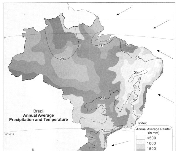

Question 1.
Considering the isotherms of Brazil, what is the average range of temperature in Brazil?
Answer:
Considering the isotherms of Brazil, the average range of temperature of Brazil is 10°C (28°C-18°C).
Question 2.
In which area does it rain more?
Answer:
It rains more in the northern and central part of Brazil. E.g., Amazon Valley.
Question 3.
From which directions are winds blowing towards Brazil?
Answer:
The winds are blowing from North East and South East directions.
Question 4.
What could be the reason behind that?
Answer:
These are permanent trade winds which blow from high pressure belt to the equatorial low pressure belt. Brazil being in the tropical zone, a low pressure area is created and wind start blowing from the ocean to the land.
Question 5.
What could be the obstruction in the way of these winds?
The Escarpment acts as obstruction in the way of the South East Trade Winds coming from the sea.
Question 6.
Which type of rainfall will occur because of these winds?
Answer:
Orographic rainfall will occur because of these winds.
Question 7.
Correlate these winds and rainfall.
Answer:
The escarpments act as an obstruction to the winds blowing from the sea and cause an orographic type of rainfall in the coastal region. Beyond the Highlands, the effect of these winds gets reduced. As a result, the rainfall is minimal.
Question 8.
In which part of Brazil are the average temperatures low?
Answer:
The average temperatures are low in the southern part of Brazil.
Question 9.
Identify the rain-shadow area in Brazil. Describe its climatic characteristics.
Answer:
The north-eastern part of the Brazilian highlands is a rain shadow region. Beyond the highlands, the effect of the South East Trade Winds gets reduced and the rainfall is minimal. Also, the temperature here is quite high. This rain shadow region is referred to as the ’Drought Quadrilateral’.
Question 10.
In which region do you find a higher temperature?
Answer:
The northern part of Brazil has higher temperature.
Question 11.
Considering the latitudinal extent of Brazil, where will you find a temperate climate in Brazil?
Answer:
The southern part of Brazil lying below 23 V4°S latitude (Tropic of Capricorn) experiences temperate climate.
Question 12.
Describe the winds blowing between 0° to 5° N and S zones.
Answer:
The winds blowing between 0° to 5° N and S zones move in the vertical direction leading to convectional type of rain. The North East and South East Trade winds are very weak in this region.
Question 13.
Which method has been used to show distribution in this map?
Answer:
The Isopleth method has been used to show distribution in this map.
Observe the given map and answer the following questions
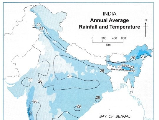
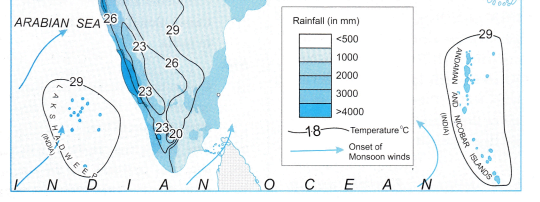
Question 1.
Which region gets more than 4000mm of rainfall?
Answer:
Western Ghats, Western Coasts of India and the northeastern region comprising of Mawsynram, Cherrapunji and parts of Assam and Arunachal Pradesh gets more than 4000 mm of rainfall.
Question 2.
Identify the regions with maximum and minimum temperatures?
Answer:
Central and North Western parts of Peninsular Plateau and islands have high temperature. Hilly regions of north, northeast and south India have low temperature.
Question 3.
In which direction is the temperature increasing?
Answer:
The temperature is increasing towards the south.
Question 4.
Identify the direction of the winds shown. What are they known as?
Answer:
The winds shown are blowing from the south west to north east direction. These winds are called Southwest Monsoon Winds.
Question 5.
Which winds are responsible for the rainfall in India ?
Answer:
South-West Monsoon Winds are responsible for rainfall in India.
Question 6.
Some part of Rajasthan is under desert? What could be the reason for it?
Answer:
The South West Monsoon Winds blow parallel to the Aravallis. As these moisture laden winds are not obstructed by the Aravallis it rains less here. Hence, Rajasthan is under desert.
Question 7.
Draw the main parallel latitude passing through India which affects its climate.
Answer:
Students are expected to draw the Tropic of Cancer.
Question 8.
In which part of Peninsular India is semi-arid climatic conditions found and why?
Answer:
(i) The part of peninsular India which has semi-arid climatic conditions are central part of Peninsula Plateau comprising parts of Central Maharashtra, Western Andhra Pradesh, Eastern Karnataka and Western Tamil Nadu. These regions lie on the leeward side of the Western Ghats and Eastern Ghats. It rains less here and a rain shadow region is formed.
(ii) Some parts of Gujarat and Rajasthan are also semi-arid as the Aravallis lie parallel and do not obstruct the South-west Monsoon winds.
Give geographical reasons:
Question 1.
Shillong gets less than 1000 mm of rainfall annually, whereas Cherrapunji/Mawsynram which is nearby get’s over 11000 mm, of rainfall annually.
Answer:
(i) Cherrapunji/Mawsynram lies in the higher altitude on the windward side of the Khasi Hills and receives rainfall from the South West Monsoon Winds.
(ii) While Shillong lies in the lower altitude on the leeward side of the Khasi Hills, so it receives less rainfall being in the rain shadow area.
Observe the pictures given below and write brief description about them.
Question 1.
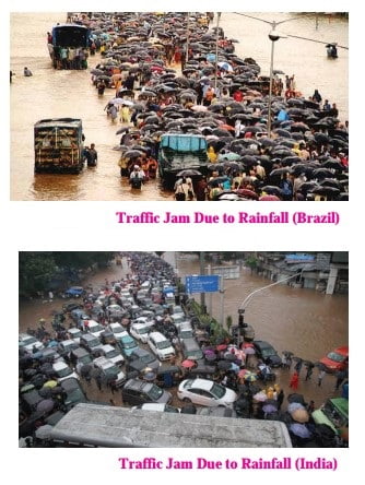
Answer:
Both the figures shows the traffic congestion during heavy rains. Due to lack of proper drainage and heavy downpour the water gets accumulated disturbing the commuting system.
Question 2.
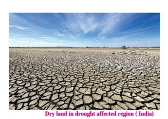
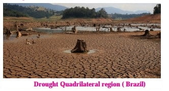
Answer:
Both the figures show the drought affected regions of India and Brazil respectively. Due to scarce amount of rainfall received in these regions the land has became dry and cannot be cultivated.
Question 3.
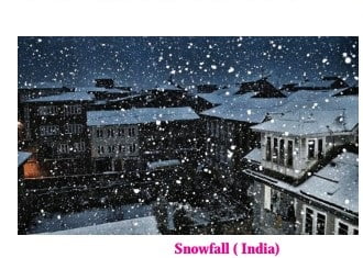
Answer:
figure shows snow fall during winter season in the northern parts of India.
Question 4.

Answer:
figure shows heavy rainfall in the Brazilian rainforest region.
Question 5.
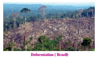
Answer:
figure shows the trees being cut down to bring land under cultivation. Deforestation is a major issue in Brazil.
Question 6.
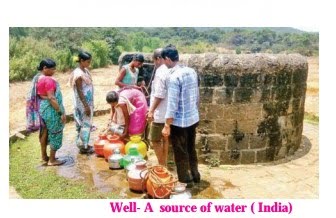
Answer:
figure shows a well from which water is used for domestic purpose.
Question 7.

Answer:
figure shows paddy fanning in India. The farmers are planting paddy. The water logged fields are shown.
Study the graphs given below and answer the following questions:

Question 1.
In which month is the highest temperature found in all the four cities?
Answer:
The highest temperature is found in the month of January.
Question 2.
In which month does it rain the most in the given cities?
Answer:
It rains the most in the month of march.
Question 3.
When does Brazil have its rainy season?
Answer:
Brazil has its rainy season from December to march.
Question 4.
Which city has the maximum range of temperature? How much is it?
Answer:
Porto Alegre has the maximum range of temperature. It is 20°C (30° C -10° C).
Question 5.
What type of climate will be found in Rio de Janeiro?
Answer:
Rio de Janeiro has mild & humid climate.

Question 1.
What difference do you find in the rainy seasons of Chennai and other cities of India? Why?
Rainy Season of Chennai | Rainy Seasons of Other Indian Cities |
(i) Chennai mainly receives rain from October to December. | Other cities of India receive rainfall from June to September. |
(ii) Chennai receives rainfall from North East Monsoon Winds. | The other cities receive rainfall mainly from South-West Monsoon Winds. |
Question 2.
What similarities do you see in the temperature curves of Delhi and Kolkata?
Answer:
The following similarities can be seen in the temperature curves of Delhi and Kolkata:
- The temperature rises from January to March.
- From March till June high temperatures are experienced.
- The temperature drops till July and remain stable in August and September.
- Thereafter the temperatures decreases.
Question 3.
Calculate the average range of minimum and maximum temperatures of all the four cities.
Cities | Average range of minimum and maximum temperatures |
Delhi | 34°C (41°-7°) |
Kolkata | 28°C (37°-9°) |
Mumbai | 17°C (34° -17°) |
Chennai | 18°C (39° – 21°) |
Question 4.
In which city is the range minimum? What can you infer about its climate?
Answer:
The range is minimum in Mumbai due to its proximity to the sea.
Question 5.
In which city is the range maximum? What can you infer from this about its climate?
Answer:
The range is maximum in Delhi. It indicates that Delhi has an extreme climate.
Question 6.
Based on the temperature and rainfall of Mumbai, comment upon its climate.
Answer:
Mumbai has an equable climate, with less variation in summer and winter temperature.
Question 7.
Classify the cites as cities with equable and extreme climates.
Answer:
Equable climates – Mumbai, Chennai, Kolkata. Extreme climate – Delhi.
Give it a try
Question 1.
Considering the various factors affecting Brazil’s climate, complete the table.
Answer:
Regions | Climatic characteristics |
(1) Amazon Valley | The climate is generally hot and humid. It receives around 2000mm of rainfall. The average range of temperature here is 25°C – 28°C. |
(2) Highlands | Hot and dry climate, low rainfall. |
(3) Pantanal | Warm and humid. |
(4) North Coastal region | Hot and humid climate. Rainfall between 1000 to 1200 mm. |
(5) South Coastal region | Mild and humid climate. |
(6) Southernmost region of Brazil | Hot summers, cool winters and snowfall. |
Question 2.
In which part of India are crops grown in a year? How is this related to the rainfall over there?
Answer:
(i) Coastal areas of Tamil Nadu in India grow rice three times a year.
(ii) This crop is taken during the retreating monsoon season.
While blowing over Bay of Bengal, the North East Monsoon winds pick up moisture and give rain to eastern coast of Tamil Nadu.
Use your brain power!
Question 1.
Group the months into seasons for a whole year according to the charts given.
Seasons | India | Brazil |
Summer | March to May | December to March |
Winter | December to February | June to September |
Answer:
Colours of Both!
Question 1.
Considering the location extent and climatic conditions of both the countries, write months according to the seasons.
Answer:
Seasons | India | Brazil |
Summer | March to May | December to March |
Winter | December to February | June to September |
Choose the correct option and rewrite the statements:
Question 1.
The climate found near the Equatorial region is
(a) hot
(b) dry
(c) humid
(d) cold
Answer:
(a) hot
Question 2.
The climate found near the Tropic of Capricorn is
(a) tropical
(b) hot
(c) temperate
(d) tundra
Answer:
(c) temperate
Question 3.
Brazil gets rainfall from
(a) North-West and South-West trade winds
(b) Westerly winds
(c) South-West and North-East
(d) North-East and South-East trade winds
Answer:
(d) North-East and South-East trade winds
Question 4.
The act as an obstruction to the winds blowing from the sea in Brazil.
(a) Himalayas
(b) Escarpments
(c) Andes
(d) Western Ghats
Answer:
(b) Escarpments
Question 5.
The coastal region of Brazil receives a type of rainfall.
(a) orographic
(b) cyclonic
(c) convectional
(d) frontal
Answer:
(a) orographic
Question 6.
Since the convergence of trade winds are weak near the equator, are not formed.
(a) clouds
(b) ocean currents
(c) cyclones
(d) tides
Answer:
(c) cyclones
Question 7.
The average temperature in the Amazon valley is
(a) 15°-20°C
(b) 13°-15°C
(c) 30°-32°C
(d) 25°-28°C
Answer:
(d) 25°-28°C
Question 8.
The Amazon valley receives around mm of rainfall
(a) 2000
(b) 1800
(c) 1500
(d) 1000-1200
Answer:
(a) 2000
Question 9.
India’s climate is of type.
(a) humid
(b) monsoon
(c) equatorial
(d) cold
Answer:
(b) monsoon
Question 10.
The diversity in the climatic conditions of India is due to the location and altitude of the place.
(a) longitudinal
(b) latitudinal
(c) equatorial
(d) tropical
Answer:
(b) latitudinal
Question 11.
The Ocean and the Himalayan ranges exert a great influence on the climate of India.
(a) Atlantic
(b) Arctic
(c) Pacific
(d) Indian
Answer:
(d) Indian
Question 12.
Orographic type of rainfall occurs in India because of the natural obstruction of
(a) Himalayas
(b) Escarpments
(c) Highlands
(d) Satpuda
Answer:
(a) Himalayas
Question 13.
As the passes through the middle of India, it is considered to be a tropical region.
(a) Tropic of Capricorn
(b) Equator
(c) Tropic of Cancer
(d) 60°S latitude
Answer:
(c) Tropic of Cancer
Question 14.
Most part of Brazil lies in the zone.
(а) polar
(b) tropical
(c) sub-tropical
(d) temperate
Answer:
(b) tropical
Match the columns:
Question 1.
Column ‘A’ | Column ‘B’ |
(1) Wettest places in the world | (a) Tamil Nadu |
(2) Driest place in India | (b) Cherrapunji and Mawsynram |
(3) Rainshadow region in Brazil | (c) Jaisalmer, Rajasthan |
(4) Climate of India | (d) Drought Quadrilateral (e) Monsoon type (f) Dry type |
Answer:
1 – b
2 – c
3 – d
4 – e
Answer in one sentence each.
Question 1.
Which natural disasters does India face frequently?
Answer:
India frequently faces natural disasters like erratic rainfall, droughts, cyclones, floods, etc.
Question 2.
Why does Brazil experience wide climatic variations?
Answer:
Brazil has vast latitudinal extent because of which it experiences wide climatic variations.
Question 3.
Which winds bring rainfall to Brazil?
Answer:
Brazil receives rainfall from the South East and North-East Trade Winds.
Question 4.
What acts as an obstruction to the winds blowing from sea in Brazil?
Answer:
The Escarpments act as an obstruction to the winds blowing from the sea in Brazil.
Question 5.
Which region is called the Drought Quadrilateral’?
Answer:
The northern part of Brazil beyond the Highlands is called ‘Drought Quadrilateral’.
Question 6.
Where is the difference in temperature negligible in Brazil?
Answer:
In Brazil the difference in temperature is negligible in the coastal regions near the equator.
Question 7.
In which zone does most of Brazil and India lie?
Answer: Most part of Brazil and India lies in the Tropical zone.
Question 8.
Which important latitude passes through the northern part of Brazil?
Answer:
The equator passes through the northern part of Brazil.
Question 9.
What is the average temperature in Amazon valley?
Answer:
The average temperature in Amazon valley is 25°-28°C.
Question 10.
Which part of Brazil has cooler climate?
Answer:
The climate is cooler in the Highlands.
Question 11.
Why do the Brazilian coasts experience mild and humid climate?
Answer:
The Brazilian coasts experience mild and humid- climate because of its proximity to sea.
Question 12.
Which type of climate is found in India?
Answer:
Monsoon type of climate is found in India.
Question 13.
Which important latitude passes through the middle of India?
Answer:
The Tropic of Cancer passes through the middle of India.
Question 14.
What diversifies the climatic conditions of India?
Answer:
The diversity in the climatic conditions of India are due to the latitudinal location and altitude of India.
Question 15.
What exerts a great influence on the climate of India and the origins of the monsoon?
Answer:
The Indian Ocean and the Himalayan ranges exert a great influence on the climate of India and the origin of monsoons.
Question 16.
In India, what obstructs the cold winds blowing from the North?
Answer:
In India, the Himalayas obstruct the cold winds blowing from the north.
Question 17.
What brings more rain in the coastal regions of India?
Answer:
The obstruction caused by the Eastern and Western Ghats brings more rain in the coastal regions of India.
Question 18.
Find out more about the different ways of classification of the seasons. For example, what is summer?
Answer:
The hot weather season is called summer. The season where the rain begins is called the monsoon. The cold weather season is called winter.
Name the following:
Question 1.
The two places in India which are considered as the wettest places in the world.
Answer:
Cherrapunji and Mawsynram.
Question 2.
Years in which Brazil has experienced snowfall.
Answer:
1879,1957and 1985.
Question 3.
The driest part of India.
Answer:
Jaisalmer, Rajasthan.
Question 4.
The state in India which receives maximum rainfall during the retreating monsoon season.
Answer:
Tamil Nadu.
Question 5.
Temperature in Kargil in winter.
Answer:
-48°C.
Question 6.
Temperature in Ganganagar, Rajasthan in the month of June.
Answer:
50°C.
Question 7.
The hills responsible for heavy rainfall in Cherrapunji and Mawsynram.
Answer:
Garo, Khasi and Jaintia Hills.
Question 8.
The winds which provide rainfall to the Tamil Nadu coast.
Answer:
North East Monsoon winds.
Question 9.
The state to receive rain foremost in India.
Answer:
Kerala.
Question 10.
The four seasons of India as per Indian meteorological department.
Answer:
The hot weather season (Summer), the season
Are the sentences right ot wrong? Rewrite the wrong ones.
Question 1.
Brazil experiences wide climatic variation due to its vast longitudinal extent.
Answer:
Wrong – Brazil experiences wide climatic variation due to its vast latitudinal extent.
Question 2.
The winds move in the vertical direction in northern Brazil.
Answer:
Right.
Question 3.
The rainfall reduces on the windward side of the Great Escarpment.
Answer:
Wrong – The rainfall increases on the windward side of the Great Escarpment.
Mark the following on the map with the given information and make an index.
Question 1.
Outline Map of Brazil.
- Winds bringing rainfall to Brazil or North East and South East Trade winds.
- Drought Quadrilateral or Rainshadow region in Brazil.
Answer:
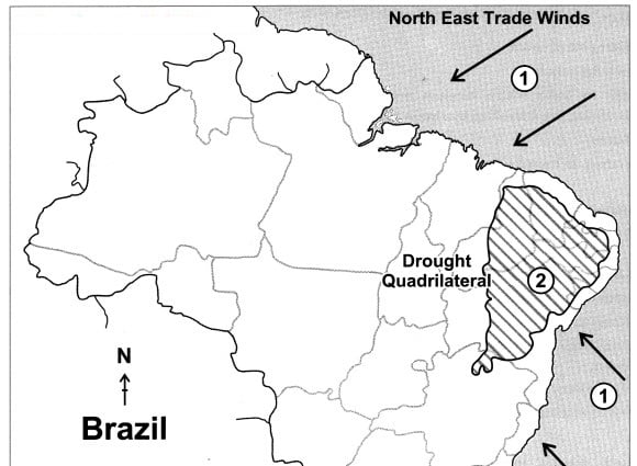

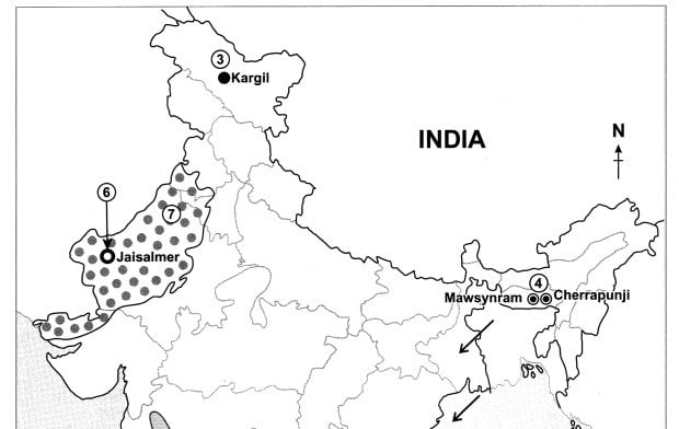
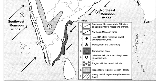
Question 2.
Outline Map of India.
- Southwest Monsoon winds or winds bringing rainfall to most parts of India.
- Northeast monsoon winds.
- Kargil or place recording lowest temperature in India.
- Cherrapunji and Mawsynram.
- Coromandel coast or the coast receiving rainfall from North East monsoon winds.
- Jaisalmer or place recording lowest rainfall in India.
- Rain shadow region of Deccan plateau.
- Region of low rainfall.
- Heavy rainfall region along the western coast.
Answer:
